Geoscience Reference
In-Depth Information
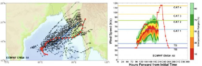
Fig. 1a (left):
VarEPS forecasts for Severe Cyclone Nargis on 23 April 2008 00UTC.
Black line with red dots denotes Nargis's observed track. Thin grey lines indicate
ensemble track forecasts from VarEPS with thick black (blue) line denoting VarEPS
ensemble mean (control) track.
Fig. 1b (right):
Maximum intensity forecast from
VarEPS shown as a probabilistic time series where colour shading denotes interpercentile
intervals. Red line indicates Nargis's observed maximum intensity.
which is about four days prior to the initiation of tropical depression advisories
by the JTWC. The VarEPS forecasts are in good agreement that the pre-tropical
vortex, that would become Nargis, would reach advisory criteria around 27
April 2008 in the central Bay of Bengal. Thereafter, based on forecasts on 23
April, the tropical cyclone is forecast to move generally towards the east-
northeast on a track that would cause the system to make landfall in Myanmar
around 30 April or 1 May with a high (60%+) probability as a hurricane and a
much lower (5%) probability as a severe cyclone/major hurricane. Nargis was
observed to intensify to category 4 hurricane level on the Saffir-Simpson
intensity scale with maximum sustained winds of 115 kts. The system made
landfall in southern Myanmar on 2 May 12UTC, propagating eastward across
the Irrawaddy delta (Webster, 2008). The forecast performance of the VarEPS
for Severe Cyclone Nargis is exceptional in nearly all facets of prediction:
tropical cyclone genesis was forecast correctly eight days in advance, ensemble
mean track errors never exceeded 375 n mi even based on pre-genesis track
forecasts, and maximum intensity forecasts, although underestimated, indicated
a moderate (30%+) probability of Nargis reaching hurricane intensity nearly
six days in advance of TC formation.
A more systematic study of all tropical cyclones in the North Indian Ocean
is now conducted to determine whether the Nargis forecast performance is
characteristic of the VarEPS. Figure 2 is a relative operating characteristic (ROC)
evaluation of the VarEPS forecasts for NIO tropical cyclone genesis using the
metrics of probability of detection (POD; also known as hit rate) and false
alarm rate (FAR; also known as probability of false detection) for all 23 tropical
cyclones occurring during 2007-2010. Figures 2a-c show the POD and FAR
of the VarEPS forecasts using 48-hr, 96-hr and 360-hr time windows calculated
at a 10% forecast probability interval ranging from 0 to 100%. Using the 48-hr
time window, the VarEPS forecasts for lead-times of one to five days in advance
Search WWH ::

Custom Search