Geoscience Reference
In-Depth Information
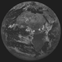
(a) (b)
(c) (d)
Figure 3.3.
Some examples of images produced by geostationary satellites: a) an MSG
image, taken on the July 27, 2006 at 12:00 GMT using visible band. The very reflective
surfaces (clouds) can be seen in white; the surfaces that absorb the short radiations (oceans)
are the dark areas. b) An MSG image, taken on the July 27, 2006 at 12:00 GMT using
infrared band. The cold surfaces are the dark areas, and the warm surfaces are the bright
areas. c) A GOES-12 image, taken on the July 27, 2006 at 18:00 GMT using visible band:
same description as image a). d) A MTSAT image, taken on the July 27, 2006 at 03:00 GMT
using visible band: same description as image a)
The result of all of these different aspects when they are linked together is the
creation of a digital image (a simple matrix of points which have a value between 0
and 255) in grayscale. The word photograph is not used as no photographic film is
ever printed. With the help of technology, color is then added to the image. The
color allocated is done so by using the operation false color. This process can
sometimes be carried out on just one channel a color is allocated to a range of pixel
values. This technique is commonly used for distinguishing between the different
temperatures of different surfaces. It is also possible to superimpose several
channels in the three basic color channels (red, green, and blue). This process is
known as color composition and it is commonly used to distinguish between
different cloud types.