Geoscience Reference
In-Depth Information
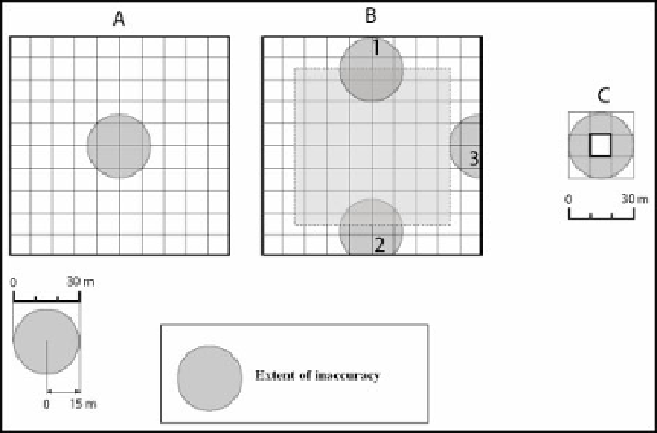
10 m with a low cost GPS (bi-frequency professional GPS are exact to the nearest
millimeter). This inaccuracy is of no importance if the interpolation has been carried
out with a rough resolution raster GIS. However, such an inaccuracy can cause
problems if the size of the inaccuracy is actually greater than the resolution size.
Figure 2.2 shows an example of two rasters with a spatial resolution of 100 m and
10 m, respectively and a positioning inaccuracy of 15 m, which is the average error
for a low-quality GPS.
Regarding the 100 m raster, the inaccuracy of 15 m in positioning does not cause
any location error when the weather station is located at or near the center of the
pixel: the area of uncertainty in which the points (provided by the GPS) can be
found are all located quite far from the pixel's boundary limits. Irrespective of the
GPS error, the location of the weather station will always be towards the center of
the pixel (example A in Figure 2.2). However, whenever the true location of the
weather station gets closer to the pixel's boundary limits, the total area for
inaccuracy increases and also becomes closer to the pixel's boundary limits (B1). In
this example, the location of the weather station in the correct pixel is not
necessarily affected. This situation can quickly change whenever the station is
located at least 15 m from the pixel's boundary limits. This occurs due to the fact
that there is a non-zero probability that the GPS will provide a location that is
outside the correct pixel (B2). The minimum probability of 0.5 is possible for a
weather station that is located at the pixel's boundary limits (B3). Therefore, with an
inaccuracy of 15 m and a resolution of 100 m, the probability that a weather station
will be placed in the correct pixel is 0.49 (this is the area covered by the square with
dashed lines in Figure 2.2b). The probability that a weather station will be placed
outside the pixel is 0.13.
Figure 2.2.
Problems associated with location inaccuracies
with a 100 m (A and B) and 10 m (C) raster