Geoscience Reference
In-Depth Information
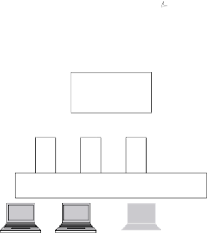
Radar
CRU
Meteosat
ECMWF
NOAA
ASCII
binary
other
OGC standardized
formats (NetCDF,
HDF5, GeoTIFF
Reading - Writing
GDAL
WWW
ArcGIS, GRASS, Google Earth, IExplorer, ….
Figure 1.3.
Simplified scheme of OGC compliant web services (GDAL stands for
Geospatial Data Abstraction Library, figure adapted from [VAN 08])
In particular, the GALEON IE (Geo-interface for Atmosphere, Land, Earth and
Ocean netCDF) Interoperability Experiment supports open access to atmospheric
and oceanographic modeling and simulation outputs. The geo-interface to netCDF
datasets is established by the Web Coverage Server (WCS 1.0) protocol
specifications. Additionally, UNIDATA unified the OpenDAP, netCDF and HDF5
data models to the new CDM (Common Data Model) and introduced a new API
(application programming interface), NcML, an XML (extensible mark-up
language) representation of netCDF using XML syntax. On a long-term perspective,
GALEON will analyze FES (Fluid Earth Sciences) requirements for simple and
effective interface specifications to access datasets and will define a more general
data model for CF-netCDF. This new data model should include non-regular data
grids and should establish metadata encodings (e.g. Climate Service Modeling
Language CSML, ncML-G). CSML is a standard-based data model described in
Unified Modeling Language (UML), and an XML mark-up language that