Geoscience Reference
In-Depth Information
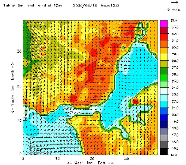
Figure 5.11.
Wind and temperature simulation in Lisbon on
a summer day (August 10, 2000 at noon) [VAS 04a] (see color section)
5.8. Modeling Lisbon's urban climate at the microscale (Telheiras city-district)
The microclimatic study was carried out at Telheiras (Figure 5.4c). The site was
chosen because it is a flat 14 ha neighborhood of Northern Lisbon of approximately
100 m altitude and is located in an area where urban growth has been increasing
since the end of the 20
th
century. Therefore, the results obtained here may be
extrapolated to nearby areas. In this part of Telheiras there is a predominance of
apartment buildings that form blocks in lines along the side of the streets; there are
also some buildings taken up by social facilities and, to the W, a strip of “tower-
like” buildings (Figure 5.4c). The main road axes are oriented in either N-S or the E-
W directions and vary between 18 and 25 m in width. The height of the buildings
also varies considerably: the tallest are around 25 m (32 m in the case of the towers).
The H:W (height to width ratio) [LAN 81] varies between 0.5 and 1.1. The
courtyards are taken up by parking spaces, social facilities and small garden areas.
The objective of this study was threefold: i) to study the microclimatic features
and thermal comfort variation within the city district [AND 08]; ii) to verify
modifications of wind speed and direction inside the city district [LOP 03]; iii) to
prescribe climate guidelines for planning at the microscale. Special measurements,
modeling, and GIS were used to develop the two first topics that will be presented