Geoscience Reference
In-Depth Information
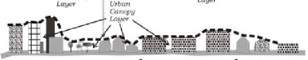
Figure 5.1.
Climatic scales and vertical layers in
urban areas. Adapted from [AND 05]
The influence of a city extends downwind into the suburban and rural areas as
well as upwards. The most intense vertical exchanges of momentum, heat, and
moisture occur in a layer comprised between the ground and the top of the buildings
and trees. It is called the
Urban Canopy Layer
(UCL, Figure 5.1) and depends
mainly of the microclimatic characteristics of the surrounding area. The
Urban
Boundary Layer
(UBL) is the portion of the planetary boundary layer above the
UCL; its climatic characteristics are modified by the urban area that lies below it
[OKE 06b].
5.4. Climatic modifications induced by settlements
As the major modifications of climate by the urban environment have been
presented in several papers and topics previously referred to and updated in recent
publications [MAT 01; ARN 03; KUT 04], only a brief overview will be given here.
Differences in the energy balance are responsible for air temperature spatial
variation, particularly the well-known urban heat island (UHI). This term applies to
the areas within the city in which the air or the surface temperatures are higher than
those of the rural surroundings. The classical scheme by Oke [OKE 87] shows UCL
air temperature rising from the suburbs towards the city center. The temperature
increase is not regular but depends heavily on urban structure. The largest difference
between urban and rural temperature is called UHI intensity. The UHI is more
frequent and more intense during night-time in most cities and during the dry season
in tropical urban areas [JAU 97]. In short, the main causes of the canopy layer UHI
are the increased downwards long-wave radiation in town, decrease of long-wave
radiation loss, high release of anthropogenic heat [SAI 04], less energy consumption
in evapotranspiration, and the night-time release of heat stored during the day within
the urban fabric [OKE 88].