Geoscience Reference
In-Depth Information
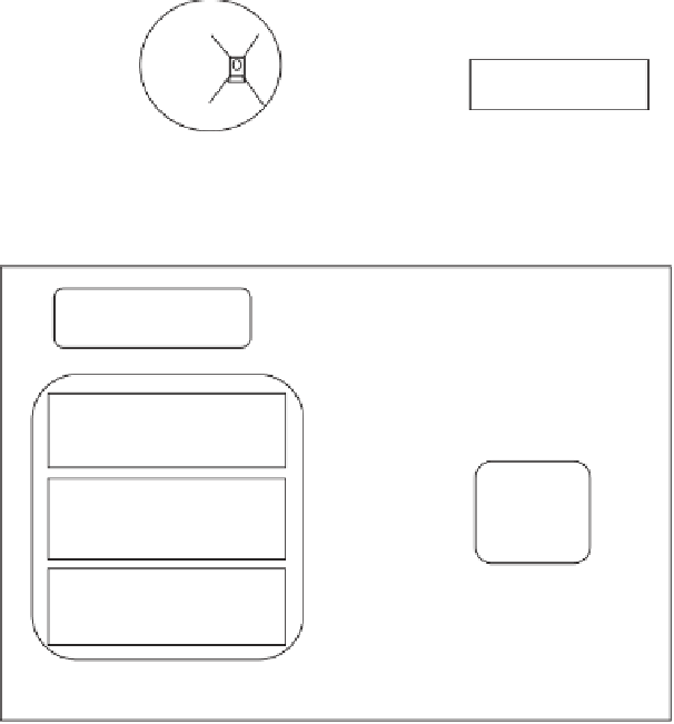
SELENE
Usuda Deep Space
Center (UDSC)
Mission Data in X-band
Mission Data
SELENE Operation and Analysis Center (SOAC)
SELENE Level 0/1
processing system
TC data in LISM data
TC L2A data
Level 2A (L2A) processing
system
SELENE
Level 2
Database
(L2DB)
TC L2A data
Radiometric Calibration
and Geometric Correction
(RGC) System
TC L2C map data
Digital Terrain Model
(DTM) production system
TC L2A data
Co-Is
in
SOAC
TC DTM/Ortho Scene data
TC DTM map data
TC Ortho map data
Co-Is in their institutes
Fig. 2. SELENE Terrain Camera (TC) ground data processing systems: (1) level 2A
(L2A) processing system, (2) radiometric calibration and geometric correction (RGC)
system, and (3) DTM production system.
4.2.
Radiometric calibration and geometric
correction system
The radiometric calibration and geometric correction will be executed in
the LISM RGC processing system in SOAC. The RGC system gets the TC
level 2A data from the L2DB system and processes dark level correction,
flat field calibration, and non-linearity calibration. The TC data processed
in the RGC system are classified into two levels: one is the level 2B (L2B)
data that has radiance values and another is the level 2C (L2C) data that
has reflectance values. We are planning that the reflectance values of L2C