Geoscience Reference
In-Depth Information
snow due to their short falling distances of about 700 m or rain due to their
melting processes or snow mixed with rain like sleet. Kangung city had new
snow of 0.1 cm corresponding to rainfall amount of 7 mm. However, GRMA
reported Kangnung city had snow instead of rain.
As times went on, easterly wind became stronger and 100% relative
humidity area also extended vertically and horizontally, making the cloud
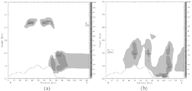
to be larger. From the vertical profile of total cloud mixing ratio (g/kg),
which represented water content within cloud, the cloud base also became
lower and lower and finally it reached less than 50 m height over the ground
in Kangnung city, especially around 18:00 LST, December 8. As the base
of a great stratocumulus cloud reached the ground surface of the city in
Figs. 3 and 4 and air temperature near the ground was 0
◦
C, droplets falling
from the cloud toward the ground should be snow without melting of snow.
From 06:00 LST through 18:00 LST, the city had continuously new snows
with a maximum amount of 3.4 cm and an accumulated amount of snow
was 9.2 cm.
Generally speaking, the area of 100% relative humidity over the ground
surface from the vertical profiles of wind, relative humidity and air temper-
ature in Fig. 3 coincided with the area of cloud formation in showing total
cloud mixing ratio in Fig. 4. As the cloud base was below 0
◦
C, the droplets
in cloud were ice crystals. However, the possibility of droplets falling down
to the ground to be snow should depend upon no melting of droplets com-
posed of ice crystals under a short distance to the ground surface.
Fig. 4.
As sown in Fig. 3, except for total cloud mixing ratio (g/kg).