Geoscience Reference
In-Depth Information
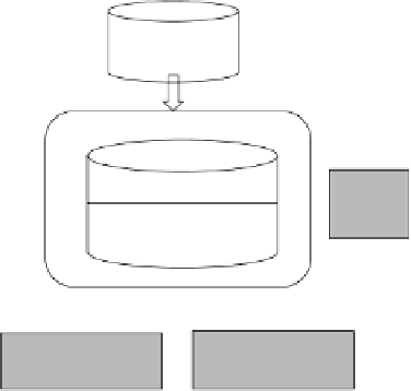
GIS environment
GIS
DBMS
Expert system
GIS
analysis
tools
Knowledge base
Facts
Inference engine
Knowledge
acquisition facility
Explanation
facility
Interactive graphical user
interface
User
Decisions
Problem
FIGURE 11.2
An ideal framework for integrating GIS and ES.
11.8 PROTOTYPE ES FOR LAND REDISTRIBUTION
This section outlines an example of a recently developed ES called LandSpaCES (Demetriou
et al. 2011), which is part of a much larger PSS called LACONISS (LAnd CONsolidation
Integrated Support System for planning and decision-making) (Demetriou 2013). LACONISS
was developed to provide support for implementing land consolidation in Cyprus (Demetriou
et al. 2012c). Land consolidation is the most favoured land management approach applied to
improving fragmented landscapes of distributed agricultural holdings and involves restructur-
ing land tenure and providing appropriate infrastructure such as roads and irrigation networks.
Land consolidation has been applied for many years in many different countries around the world
(FAO 2003, 2008). It includes the process of land reallocation, which can be further subdivided
into two subprocesses of land redistribution and land partitioning. Land redistribution involves
decision-making by combining current legislation, existing land tenure structures, rules of thumb
and the experience of the planners. The output of this process is a preliminary plan that divides
the area to be consolidated into land blocks. Each land block, which is a subarea enclosed by
roads, physical boundaries and/or the external boundary of the consolidation area, contains a
set of points representing the approximate centroids of the new parcels. Each centroid has a set
of attributes including the size of the new parcel, its land value, landownership details and other
relevant information.
Land redistribution is carried out in a semi-computerised manner and hence it is a time-
consuming process in Cyprus. Land redistribution has therefore proven to be an ideal candidate for
the development of a prototype ES embedded within a GIS. Moreover, the land redistribution prob-
lem fulfils the criteria to be solved using an ES based on the five questions posed by Giarratano and
Riley (2005) as outlined in Section 11.3. For example, since land redistribution is a semi-structured
decision-making problem based on legislation, existing land tenure, rules of thumb, heuristics and
experience (Q3), this problem cannot be solved effectively by conventional programming (Q1).