Geoscience Reference
In-Depth Information
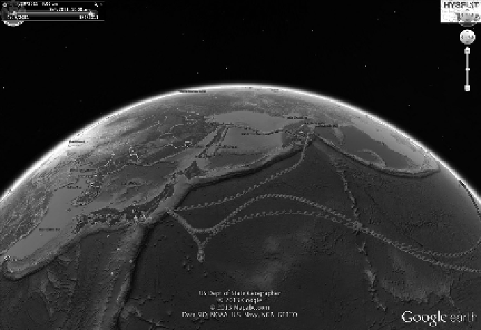
FIGURE 4.4
Google Earth as a base layer for possible trajectories of the radioactive plume from the
Fukushima Daiichi nuclear disaster. The different lines represent different possible paths of the plume
(HYSPLIT, Possible trajectories of the radioactive plume from the Fukushima Daiichi nuclear disaster, 2014,
available at http://forecast.chapman.edu/images/japan/tranj.kmz, accessed on February 10, 2014).
as a valuable tool in scientific applications (Yu and Gong, 2012) ranging from exploring the cryo-
sphere to mapping the spread of diseases, to urban growth and planning (e.g. Pu and Vosselman,
2009) or to visualisation of the impact of future wind farms (e.g. Wolk, 2008).
However, to fully utilise the Digital Earth concept as put forward by Gore (1998), we have to also
consider that the idea behind a Digital Earth is to provide a
highly detailed
and
immersive
environ-
ment for users to explore the Earth. Building detailed 3D models, especially those related to cities,
relies on a number of fields ranging from computer vision, computer graphics, remote sensing and
photogrammetry (Rau and Cheng, 2013). For example, in order to achieve a high degree of realism,
we need a detailed 3D object, data and accompanying texture information (Lange, 2001). Moreover,
we need methods for storing and analysing 3D data (Abdul-Rahman and Pilouk, 2008). This relates
to the notion that building traditional 3D city models was very time-consuming and labour inten-
sive, requiring manual reconstruction from 2D geographical information sources whereby building
outlines are extruded or elevated to create a crude 3D model (Pu and Vosselman, 2009).
For building 3D-rich environments, we can take advantage of developments in data capture.
Examples include airborne and ground-based laser scanning (LIDAR) that offers the ability to extract
a dense 3D point cloud from which buildings can be reconstructed (e.g. Pu and Vosselman, 2009; Heo
et al., 2013). However, such methods only focus on the exterior geometric characteristics of the built
environment, resulting in
empty shells
that lack any human dimension associated with the buildings.
Motivated by this gap, work is actively being pursued in this arena. For example, Smith and Crooks
(2010) enrich such
empty shells
with residential and commercial property information sourced from
other databases within the Greater London Authority to explore the relationship between urban form
and function. A truly comprehensive treatment of the issue of
empty shells
really requires informa-
tion about the internal structures of buildings. For this, we can turn to CityGML (Gröger and Plümer,
2012), an OGC standard for the storage and exchange of 3D city models based on GML. CityGML
is different from KML and Virtual Reality Modeling Language (VRML), which are often used to
build 3D city models as these are purely geometrical or graphical models of the built environment.