Geoscience Reference
In-Depth Information
120
°
E
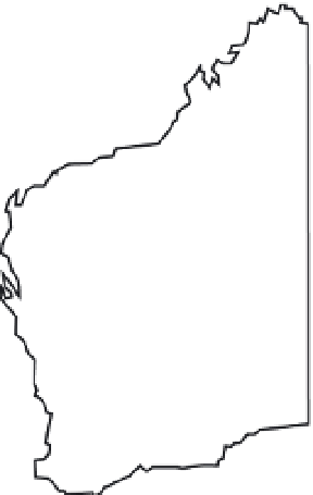
Cape Leveque
North West
Cape
Western Australia
26
°
S
N
Perth
Figure 5.12.
Location map showing North West Cape and Cape Leveque, Western
Australia.
deposits with marine faunal inclusions atop a 30 m high headland, erosion
(plucking) of bedrock and subsequent overturning of the dislodged blocks atop
thesame headland, and fluvial-like channels, cavettos (scoop-shaped features in
channel walls) and pot holes carved into regolith across the headland.
The boulder field at Cape Leveque includes clasts up to 5.5 m (
a
axis) and
4m(
b
axis). They have been transported across the shore platform and deposited
at the base of the headland. Most boulders are imbricated with seaward dips and
have their
a
axes aligned parallel to shore. The imbrication and alignment record
therefraction of the waves around an island 300 m offshore. The shore parallel
alignment of the boulders on two sides of the headland differs by about 90
◦
.
Boulders on the west side dip west, those on the north side dip north.
The headland at Cape Leveque is composed of deeply weathered, saprolitic,
horizontally bedded Cretaceous siltstone and sandstone. The base of weathering
is at the level of the shore platform, which consists of the unweathered part of
therock unit. Many boulders at the headland base are unweathered Cretaceous
strata. This suggests they must have come from the shore platform, not from
collapse of the headland cliff. The boulders accumulated at the headland's base
where the transporting velocity of the flow was checked. Seaward of the boulder
field the shore platforms are largely devoid of boulders. In places joint-bounded
blocks have been partly lifted and these blocks now rest with one edge, usually
thelandward edge, upon the shore platform and the remainder of the block
sitting within the cavity from which it came. These blocks are often much larger


Search WWH ::

Custom Search