Geoscience Reference
In-Depth Information
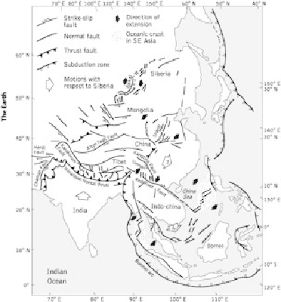
15. Tectonic map of Southeast Asia showing the principal fractures resulting from the
collision of the Indian subcontinent and the motions of China and Indochina as they
are squeezed to one side.
As you head north across the flat Ganges plain, the first of these giant thrust faults forms
a sharp feature. Here and there in the line of hills are sediments that were once deposited
on the river bed but are now lifted tens of metres above it, yet they are only a few thou-
sand years old, suggesting that there has been sudden and dramatic uplift in earthquakes.
These hills are the foothills of the Himalayas which rise in a series of ranges stretched out
to the east and west. Each line of mountain peaks corresponds approximately to another
huge wedge of continental rock. The rocks exposed in the Himalayas today are mostly an-
cient granites and metamorphic rocks that have been uplifted from deep within the contin-
ents. The folded sediments scooped up from the floor of the Tethys Ocean lie north of the
mountains on the edge of the Tibetan plateau. Behind them is a line of lakes corresponding
to the original join between the continents, known as the suture.
An old, cold continent such as India is hard and relatively rigid. The part of Asia it collided
with is relatively young and soft. Just as the hot mantle can undergo solid flow, so can
crustal rock. We think of rock as we find it at the surface, hard and brittle, but crustal min-
erals such as quartz can flow like toffee at temperatures of only a few hundred degrees
Celsius, just as olivine can deeper in the mantle. Some of the best models for the collision
of India with Asia come if India is taken to be a relatively solid continent being driven into