Geoscience Reference
In-Depth Information
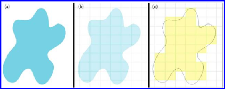
Figure 3.7 (a) Vector image, (b) grid (raster) overlain on curve, and (c) raster image
in yellow.
Raster images look and feel like a paper map; this format can be updated
frequently using raster patches, but this format does not have the capability
to show denser data when zooming in. When the image is rotated the text
remains fixed and is therefore not upright.
These observations led us to attempt to encapsulate the general merits and
limitations of raster and vector images.
• Raster image: Merits.
• Photographs and .jpg iles are raster images. If a raster image is
to be aligned with a map, it makes sense to choose a raster rep-
resentation for the map so that the pixels will overlay correctly
throughout the image.
• These images are easy to edit (in a variety of ways, including the
editing of the color's hue and saturation). They can display fine
nuances in light and shading. They are often a preferred file for-
mat for conventional publication not concerned with scalability.
• These images have the option of applying ilters for visual enhance-
ment such as drop shadows, inner or outer glow, and so forth.
• Raster image: Limitations
• These images have a set resolution (coming from pixel base) and
will become fuzzy (pixelated) when enlarged. These images are
not truly scalable.
• When zoomed in on, curves on these images may become jagged
in appearance, due to the corners on the pixels.
• Vector image: Merits
• Can be scaled to any size and will retain its sharpness.
• Can zoom in on the screen and see smooth, rather than jagged,
edges independent of scale.
• Useful for highly geometric images, such as logos, for example,
that can be perfectly scaled to fit on media of highly variable size
(stationery, business cards, etc.)
Search WWH ::

Custom Search