Geoscience Reference
In-Depth Information
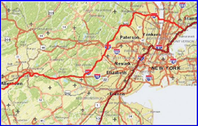
Figure 10.13 Trucking activity, a closer look showing difference between the fast-
est route (in red) versus the shortest route (in dark red). Source of base map: Esri
software.
In the next activity, you will have the opportunity to conduct a deeper inves-
tigation, in particular, considering the type of traffic on streets, in your quest
to locate the optimal site for a high speed Internet café in Denver, Colorado.
10.4.5 Find the busy streets—Denver
In Chapter 3, you created a map called “InternetCafeSites” as part of your
investigation on siting the optimal location for your high-speed Internet café,
using Census data. The activity below draws on that earlier map that you cre-
ated. A link to the full study is provided below.
In Chapter 3, you found regions within 1 kilometer of a high school, univer-
sity, or college—one component of solving the problem of where to locate the
café in Denver. In Chapter 7, you found Denver neighborhoods in which the
percentage of 18 to 21 year-olds is greater than 10% of the total population of
those neighborhoods. Here we solve the remaining task of finding the busy
streets in Denver.
Make a unique value map for roads, symbolizing the roads based on the attri-
bute CFCC2 (Census Feature Class Code 2). Be sure to “add all values” to see
all the possible values for CFCC2. Zoom in on the map when you are done,
using the “I” identify button to answer the following questions: What is the
CFCC2 code for the three most major road types in Denver City and County?
In other words, these are the roads that carry the most traffic. What other
Search WWH ::

Custom Search