Geoscience Reference
In-Depth Information
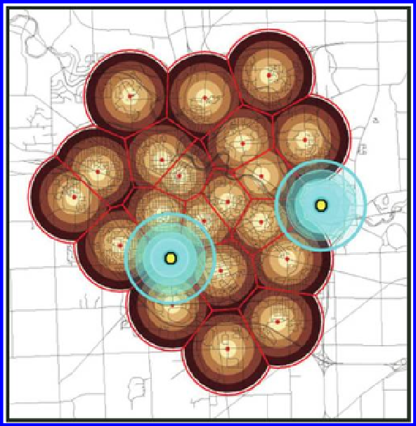
Figure 8.1 Cyan concentric circles target locations for two new tornado sirens, repre-
sented as yellow dots. These two new locations complete the coverage for Ann Arbor.
Source: Arlinghaus, S. L. 2003. Tornado Siren Location: Ann Arbor, Michigan.
Solstice: An Electronic Journal of Geography and Mathematics. Volume XIV, No. 1.
Source of data; base map: City of Ann Arbor; Esri software.
decay over distance. Scale is local enough that the curvature of the Earth, and
associated distortion of buffers or Thiessen polygons, may be viewed as flat.
Thus, buffers of points appear as circles. The boundaries generated by these
intersecting circular buffers (mostly at the 5000 foot distance) are precisely
the edges of the Thiessen tessellation, as we saw in geometric constructions
in Chapter 3. Thus, the buffers fit exactly within the Thiessen tessellation and
serve as a proximity contouring of the urban surface.
What became clear from the map was that almost everyone was within 5000
feet of a siren; existing local wisdom at the time suggested that one mile was
the outer edge for siren audibility. Two exceptions were evident: One south-
west of downtown near The University of Michigan golf course and one at
the eastern edge of the city. The position for a new siren near the golf course
was easy to determine; the uncovered area was small and there were very few
choices for position. The location for a new siren in the broader area to the
east was found by digitizing the boundary of the uncovered area, calculating
the centroid of the digitized region, and then using the centroid as the pro-
posed siren location. In constructing the actual siren, centroid position gave
Search WWH ::

Custom Search