Geoscience Reference
In-Depth Information
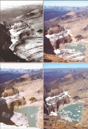
FIGURE 8.1
Grinnell.Glacier.from.the.summit.of.Mt..Gould,.Glacier.NP..Upper.left.(1938):.Oblique.
view.of.Grinnell.Glacier.shows.decreased.glacier.area.and.reduced.depth.of.the.glacier.along.the.cirque.
wall.where,.prior.to.1938,.the.ice-surface.elevation.was.high.enough.to.connect.with.the.upper.band.of.
ice.(T.J..Hileman,.Glacier.NP.archives)..Upper.right.(1981):.(C..Key,.U.S..Geological.Survey.[USGS])..
Lower.left.(1998):.(D..Fagre,.USGS)..Lower.right.(2006):.(K..Holzer,.USGS)..
Dominant Climate Indicies
PDO
PNA
SOI
NAO
NAO and PDO
NAO and PNA
NAO and SOI
PDO and SOI
PDO and PNA
PNA and SOI
PDO, PNA and SOI
NAO, PDO and SOI
NAO, PNA and SOI
FIGURE 9.3
Dominant.climate.indices.for.the.gridded.precipitation.data,.determined.using.Maximum.
Basic.Probability.Assignment..