Geoscience Reference
In-Depth Information
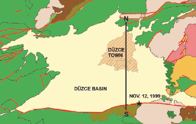
Fig. 18.6. Geological map of theDuzce basin and surrounding area, including the
epicenter of the Nov. 12 1999 earthquake and the trace of the NS cross-section
considered inthis study
the coupled analysis of the effects induced by the seismic source, the propagation path,
andthegeological siteconditions atgroundsurface.AsshowninFigure18.6, theDuzce
basin extends north of the right-lateral strike-slip fault, a major northern strand of the
North Anatolian Fault, which ruptured during the Nov. 12 earthquake.
The seismic response of a NS cross-section of the basin, passing through the center of
the town, was analyzed. To reduce the computational effort required by accounting for
the simultaneous effects of the seismic wave propagation from the Duzce fault rupture
and of the sedimentary basin where the town is located, the Domain Reduction Method
(DRM), devised by Bielak et al. (2003), was adopted. This is a rigorous method for
substracting the analysis into two coupled steps, as shown in Figure 18.7. In the first
step, a 3D analysis of the seismic wave propagation from the source into a layered half-
space has been carried out using the approach by Hisada and Bielak (2003), while in the
secondstep,theSpectralElementMethod(SEM)developedbyFacciolietal.(1997)and
implemented in the software GeoELSE (Stupazzini, 2004) has been used to simulate the
2D wave propagation in the region of interest. The DRM implementation in the spectral
element code is illustratedby Faccioli et al. (2005) and Stupazzini et al. (2006).
A detailed presentation of the numerical procedure and results, together with a compari-
son with ground motion recorded at the accelerograph station inside town, can be found
in Scandella et al. (2007). We show here only some relevant results for ground strain