Geoscience Reference
In-Depth Information
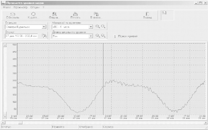
Fig. 6.3 Example of telemetric data presentation at the Sakhalin Tsunami Center, data were
received from the registrator in Severo-Kurilsk. The mark indicates the onset of the front of
the Indonesian tsunami of December 26, 2004
The telemetric complex comprises a pressure gauge PTX160 of the Druck
company
0
.
1%), a universal device for
data collection and transformation, 555 DCP of the Handar company, including
a radio transmitter of the satellite data collection system via GOES or GMS-5
and a power supply. The complex is also equipped with an antenna for satellite
communications. The distance of the pressure gauge from the coastal device can
amount to 1.5 km. Usually, the gauge is put in a pipe with draining openings, or
inside a mareograph shaft at a depth of about 3 m.
Telemetric information on the sea level is received and processed in national
tsunami warning centres. An example of such registration at the Sakhalin Tsunami
Center (Yuzhno-Sakhalinsk) is shown in Fig. 6.3. The tsunami wave due to the earth-
quake of December 24, 2004, in the Indian Ocean reached Severo-Kurilsk in 41 h
17 min, its amplitude amounted to 29 cm.
Until recently all ideas of the character of tsunami wave evolution in the open
ocean were based exclusively on coastal measurements. In the 1960s-1970s
S. L. Soloviev proposed an essentially new method for effective prognosis, based
on the registration of waves far from the coast [Soloviev (1968); Jacques, Soloviev
(1971)]. Upon having undergone significant technological development [UNESCO
Tech. Pap. (1975); Cartwright et al. (1979); Gonzalez et al. (1987), (2005)], this
method is at present applied in the USA (DART) and Japan (JAMSTEC).
The creation of an automatized system of level observation in the open ocean
represents a promising way for providing reliable and timely tsunami warn-
ing. Moreover, deep-water-level measurements are important for developing an
(pressure
measurement
precision:
±