Geoscience Reference
In-Depth Information
The lowlands of Holland seems in jeopardy by water from four different fronts: by
high rivers, stormy seas, heavy rains, and also from drought.
dry summer
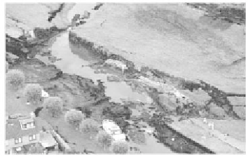
Figure 17.10 Bosom embankment of peat; collapse during a dry summer, in 2003
These secondary embankments are of a typical construction, built from peat and
organic clay centuries ago in the original swamps, embedding a lowland canal to
which the surplus water of the area was and is being pumped and transported to the
sea. These dikes served peat mining for salt production and turf. When the peat
mining stopped the resulting lowland, called polder, was used for cattle. At present,
these regions settled about 1.4 metres below canal level and are developed into
modern living areas. A peaty embankment has a typically moderate slope, around
1:10 (Fig 17.10). Peat is light and if not compressed it is relatively permeable. To
perform its function it must be saturated, and usually the infiltration from a steady
canal level provides sufficient recharge to maintain the water content. In fact, the
water retaining capacity comes from the groundwater weight. When peat dries out,
however, it shrinks significantly and it becomes like cork. Investigation after the
event revealed that shrinkage and uplift triggered the slide. Following this failure, it
became clear that our knowledge of the mechanical and chemo-biological
behaviour of peat is poor. Before, no one thought to consider dry embankment
behaviour. Nature may have still many surprises. Our knowledge of peat and
organic clay needs improvement.
Liquefaction and piping
In case of high water levels, the latest dike evaluation has shown that piping
induces relatively large failure probabilities. The process may involve micro-
liquefaction and whether coarse sand is less vulnerable is yet uncertain. In low-
density sands, recent small-scale tests show that a different erosion process may
occur, i.e. the pipe starts upstream and moves downstream by local densification.
In addition, the likelihood of flooding is not well predictable in areas with loosely
packed sands. The measurement of the local density (porosity) in the field is


Search WWH ::

Custom Search