Geoscience Reference
In-Depth Information
and high-peaked river discharges rings the warning bell for risk engineering in
design and integral maintenance of water-defence structures.
B
HISTORY OF DUTCH DIKE ENGINEERING
Before building dikes
A large part of the Netherlands is situated under sea level. Without dunes and
dikes half the country would be submerged. In general, one speaks of lowlands and
the name "Netherlands" is appropriate. Since the last glacial period, which ended
about 10,000 year ago, the sea level is rising and the coastline receding. This
process took place intermittently. Repeatedly, the sea was aggressive (transgression
period), and other times relatively quiet (regression period). During the
transgression periods the sea intruded deeply into the inland. During the regression
periods large peat areas developed in the eroded parts (Holland, Utrecht).
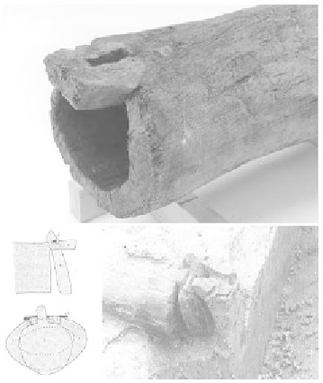
Figure17.2a Ancient valve-sluice, Roman
period (Schiedam, Netherlands)
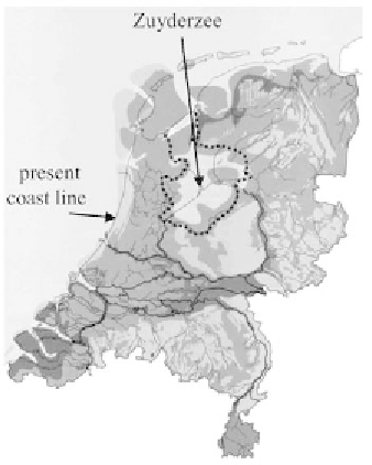
Figure 17.2b The Netherlands ~ 800 AD
light: sand, medium: peat; dark: clay
Natural sea walls along the coast could withstand the high storm surges,
although the sea swallowed large areas. In the Roman era the possibilities for land
cultivation improved and small villages arose at the borders of the peat marshes
and inland creeks. One of the known gullies in that time was the Gantel running
from the river Maes to the north, passing Delft. Shipping became feasible when in
12 AD Drusus ordered channels to be built from the Rhine northwards, and in 47
AD the Roman warlord Corbulo ordered the digging of a southern channel
connection to the river Rhine. Remnants of small dams and valve-sluices made
from hollow trees were found in the area (Fig 17.2). The higher dunes ascended
only ten centuries ago. In the late Middle Ages, the sea became more dangerous
Search WWH ::

Custom Search