Geoscience Reference
In-Depth Information
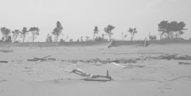
building foundations. The tsunami inundation was reported to be 9.5 meters deep,
extending inland for three to five kilometers. One of the few standing buildings was
the Arahama Elementary School, a building designated for vertical evacuation.
Although the waves leveled almost everything inland of the seawall, the seawall itself
and the fronting beach were in good condition. The beach was about 100 meters wide
with a one meter (plus or minus) sand berm, a cusp face and salient formations
behind the breakwaters. This beach performed extremely well.
Figure A.15 The Arahama Beach seawall's ocean-side slope protection
(Source: Ron Noble)
Our last site visit of the day was to the north side of the Natori River, where a new
waterfront development adjacent to the landside had been leveled.
After that, we drove to Tohoku University to meet with Drs. Imamura, Motosaki,
Imai, Sugawara, and Udo, all from the school's Tsunami Engineering Laboratory and
Disaster Control Research Center. They are involved in many aspects of tsunami
research, including the preparation of tsunami hazard maps and the study of sediment
transport during a tsunami. We talked about the tsunami, their hazard planning
efforts, and coordination with the national, prefecture and local government officials
who are trying to develop appropriate redevelopment plans. Tohoku University is in
Sendai, very close to the earthquake's epicenter, and unfortunately several of the
buildings on campus had been seriously damaged by the seismic event. Thus, the
Disaster Control Research Center is now addressing the broad Tohoku-area damage
issues as well as local campus damage concerns.
We met with the Tohoku tsunami group for about an hour and then headed for our
Sendai hotel. Downtown Sendai retains a big city atmosphere, with no signs of the
nearby coastal destruction to its shoreline and airport.
Search WWH ::

Custom Search