Geoscience Reference
In-Depth Information
From here, we proceeded to the city of Kamaishi to view the port's breakwater.
Located in 63 meters of water depth, the Kamaishi Breakwater is the deepest
structure of its kind in the world and consists of a rubble mound base topped with
concrete caissons 25 meters high with five meters of freeboard. We had arranged to
view the breakwater close up with a chartered boat today; however, high winds and
rough seas prevented us. We opted instead to view the breakwaters from atop a high
hill around the harbor.
Next, we proceeded further south to Rikuzentakata, which was one of the most
heavily impacted areas along the coast. This community occupies a very low, wide,
and flat plain, which was devastated by a 15-meter-high tsunami wave with a more
than 19 meter run-up. It is reported that more than 10 percent of the town residents
perished in the event or are still missing. The coastal structures we surveyed here
included two eight-meter- tall coastal dikes that had been separated by a 50-meter-
wide vegetative buffer and fronted by a beach and more vegetation. The beach, outer
dike and vegetative buffer were completely erased by the tsunami. We were surprised
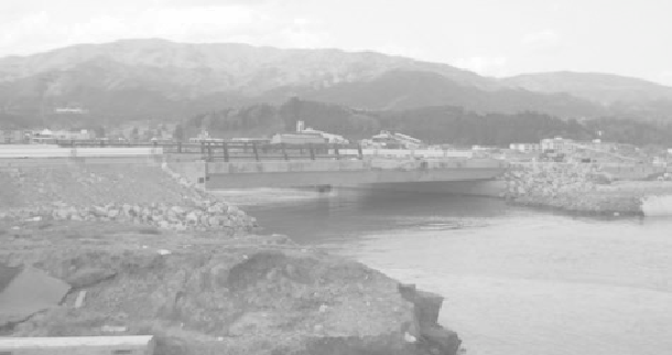
to find, however, that many low-lying bridges directly on shore survived, despite the
destruction of the buildings and taller structures around them.
Figure A.9 Despite the massive destruction of vertical walls and buildings
in Rizukentakata, many low-lying structures such as this bridge survived
the tsunami largely intact.
(Source: Brian N. Jones)
Kesennuma fishing port was the final stop for us today, about 75 kilometers south of
Kamaishi. The port is well protected within a sheltered part of the coast, and thus
does not possess the extensive shore protection structures we have seen elsewhere.
The damage to the port was extensive, with evidence of overturned oil tanks that had
caught fire during the inundation, further adding to the devastation.
Search WWH ::

Custom Search