Geoscience Reference
In-Depth Information
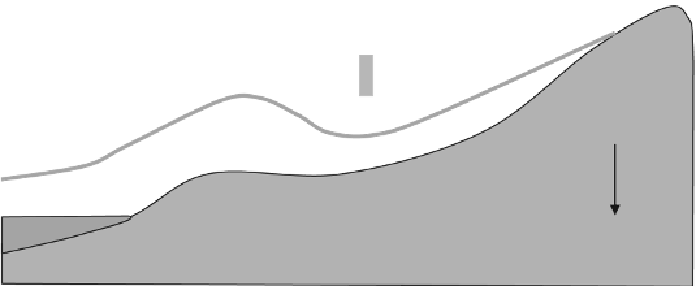
tide level at the time of the event at the maximum distance from the shoreline. The
observed level of the water above the tide level at the time of the event at
intermediate locations was called the
inundation height
.
Runup
Inundatio
n height
Inundation
Ground elevation
Mean Sea Level (MSL)
Tide level
at time of
event
Distance from shoreline
Figure13.Definitionsketchfortsunamirunupandinundationmeasurements
Figure 14 summarizes the runup and inundation measurements the field teams took
through July 15, 2011. The water levels measurements, adjusted to reflect the tide
levels at the time of the tsunami, indicate the most heavily affected coastline segment
spanned from the Aomori prefecture on the northern end of Honshu south to the
Ibaraki prefecture in the Kanto region. This area consistently experienced water
levels in excess of 5 meters. Between the port areas of Momoishi and Hachinohe near
Misawa and the southern boundary of Fukushima prefecture, runup heights
consistently exceeded 10 meters with maxima of 38 to 40 meters above tide level at
several locations in the Iwate prefecture.
Figure 14 shows the distinct difference in tsunami runup and inundation heights
across the Oshika peninsula. North of the peninsula, in Sanriku, wave heights far
exceeded wave heights further south, in Sendai and Fukushima. On the Sendai plain,
the incoming tsunami ranged from 12 to 20 meters in depth and propagated up to 4
kilometers inland. Although the radiation hazard around Fukushima prevented data
collection around the Fukushima nuclear power plants, plant personnel reported that
51 minutes after the earthquake, a wave 13.1 meters high overtopped and damaged
the Fukushima Dai-Ichi seawall, and interrupted emergency back-up power (TEPCO
2011).


Search WWH ::

Custom Search