Geoscience Reference
In-Depth Information
Figure7.GreatEastJapanearthquakeforeshockandaftershocksequencefrom
March8toMarch16,2011(HayesandWald,USGS2011)
Recent advances in Global Position Satellite (GPS) technology have allowed
scientists to establish extensive monitoring systems to report both earth and sea
displacements in a very short time after an event. For both the Great East Japan
earthquake and the 2010 Maule Chile earthquake, these systems captured provided
valuable data by capturing the motion produced by the earthquake. The nationwide
GPS array of Japan, GEONET (GPS Earth Observation Network), consists of 1200
GPS permanent stations. Additionally, the Coast Guard of Japan along with Tokyo
University installed and currently monitors an array of five GPS sensors located on
the sea floor. Displacements from the Great East Japan event followed the pattern
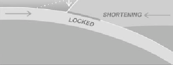
typical for locked plate boundaries in a subduction zone shown in Figure 8. At a
subduction zone boundary, the locked plate, shortened and uplifted before the
earthquake, undergoes extension and subsidence during co-seismic motion.
Figure 8. Sequence of pre and co-seismic displacements at a subduction zone


Search WWH ::

Custom Search