Geoscience Reference
In-Depth Information
Surface (km
2
)
200
1.6
180
1.4
160
1.2
140
Shore development (P
shore
)
1
120
100
0.8
80
0.6
Perimeter (km)
60
0.4
40
0.2
20
Urban shoreline (km)
0
0
25
B
.
C
.
1868-1875
1926-1935
1937-1947
1969 -1981
1994
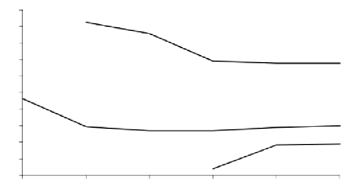
FIGURE 9.3.9
Evolution of the perimeter and surface of the Mar Menor Lagoon from 25
B
.
C
.
to the present. Loss of surface and perimeter up to the 19th century probably was related to
segmentation processes and fill-up of marginal embayments by erosion of surrounding lands.
During the 20th century the surface still decreased but the perimeter increased as a consequence
of land reclamation for different human uses. This led to an increase in the shore development
index and a corresponding increase in the vulnerability of the system.
are nine yachting harbors, lodging 2784 boats, located along the lagoon's coastline,
some of them less than 800 m away. At present, the major urban development takes
place inland, perpendicular to the coastline.
Land has been reclaimed for construction of new beaches and promenades on
the order of 270,275 m
2
with 640,456 m
3
of sand, much of it extracted from inside
the lagoon during 1987-1988. The resulting environmental stress was exploited
by opportunist species such as floating masses of
Chaetomorpha linum
and mead-
ows of
Caulerpa prolifera
in some areas. As a result, clean sandy bottoms were
replaced by muddy ones with increased organic matter,
32
causing a change in the
species composition of the benthic fish assemblages. At present, a new land
reclamation plan of about 500,000 m
2
will create and expand beaches at the inner
part of La Manga.
El Estacio is the only navigation channel that connects the Mediterranean Sea
with the lagoon. It was artificially created in the early 1970s by dredging and
widening one of the
golas
up to 30 m wide and 5 m deep at its minimum section.
Opening this channel caused major changes in the lagoon dynamic. The modification
of the renewal rate of the water changed the lagoon's physical and chemical prop-
erties, mainly salinity and extreme temperatures, which permitted access to new
colonizer species, thus altering the lagoon's community structure with detrimental
effects on fisheries.
On the other hand, agriculture in the watershed has experienced a great transfor-
mation in the last 15 years. Since 1986 surface waters diverted from the Tajo River,
400 km north, to the Segura River have changed extensive dry crop farming to


Search WWH ::

Custom Search