Geoscience Reference
In-Depth Information
CANADA
ATLANTIC
OCEAN
PACIFIC
OCEAN
GPR Suitability
Index
Potential for
GPR Applications
0-1
1.1-2
2.1-3
3.1-4
4.1-5
5.1-18
No Data
State Boundaries
Interstate Highways
State Capitals
High
Moderate
Low
MEXICO
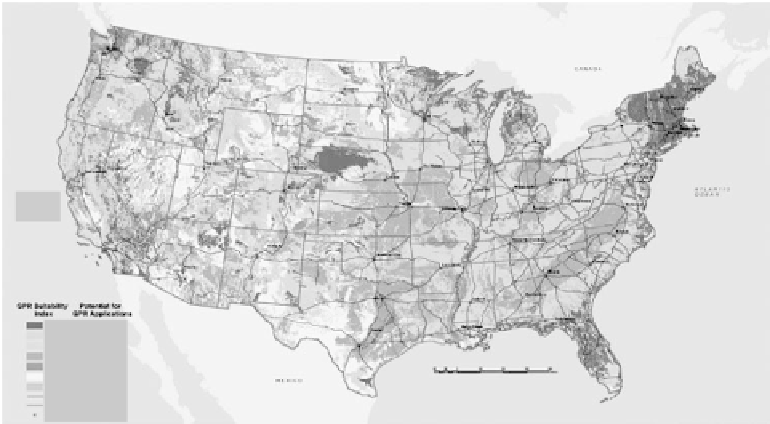
fIGURe 3.1
Ground-penetrating radar soil suitability map of the conterminous United States as presented
by Doolittle et al. (2002).
Rico as to their potential for GPR applications. This was an excellent step in assessing all the soils in
the United States for the radar, even though it was done on a national scale. Some of the maps they
created included saline and sodic soils, and the proportion of soils with less than 18 percent clay. A
more detailed map was created by Doolittle et al. (2002) and is shown in Figure 3.1. On this map,
notice that the Midwest United States, the dominant agricultural region in the United States, has a
low potential for GPR use. Thus, research in using GPR for agricultural purposes has not developed
as quickly as it has for environmental intentions. This point also was discussed by Collins (1992)
when she pointed out that Mollisols and soils with mollic epipedons (principal soils in the Midwest)
have a low potential for GPR. But even so, other geophysical instruments can be used to study soils
where the radar has slight potential. Doolittle and Collins (1998) compared EM induction and GPR
in areas of karst in Florida and Pennsylvania. They determined that GPR was the geophysical tool
to use in Florida where the soil has low pH, low cation exchange capacity (CEC), and low base
saturation in comparison to the soils in Pennsylvania which were characterized by relatively high
pH, high CEC, and high base saturation. The soils studied in Pennsylvania were better suited for
EM applications. Agricultural applications of GPR include investigations that have a direct influ-
ence on agricultural production and management. Agricultural production and management may be
affected by a limited soil depth restricted by bedrock, hardpan, or a shallow water table. In these
soils, plant roots are constrained in growing volume.
Also, agricultural production and management includes using soil (e.g., peatland) as fuel. Many
countries (e.g., Ireland, Sweden, Canada, Finland) mine peatlands for the organic soil that can be
burned and then have a restoration process to reestablish the land for future generations. Finn-
ish peatlands are a very valuable resource for the wealth of the country. Thus, Hanninen (1992)
compared traditional drilling field methods used in Finnish peatlands to determine organic matter
thickness and properties to radar data. His conclusions were that GPR could be used to locate the
interface between peat and the material below provided that there is a significant difference in mois-
ture content; and various peat layer types and aquatic sediments could be identified by radar.
The list of literature that has had success with GPR includes the following:
•
Mapping bedrock depth in a glaciated landscape in Maine (Collins et al., 1989)
•
Microanalyses of soil and karst on the Chiefland Limestone Plain in Florida (Collins et al.,
1990)