Geoscience Reference
In-Depth Information
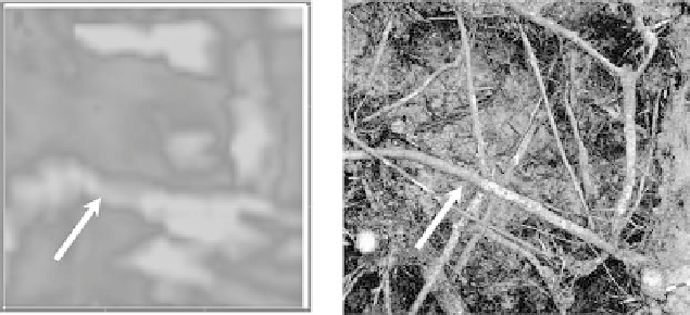
fIGURe 30.5
Visual correlation between ground-penetrating radar (GPR) data and coarse root excavation
pits. Large roots spanning the entire length of the validation pit were most likely to be observed in the GPR
data. Each GPR data image (left) represents a “slice” of the three-dimensional profile at the appropriately cor-
related depth with a viewing depth of 15 to 20 cm.
scrub-oak site. The data were processed with RADAN software which permits intersections of
the X-Y scans to be interpreted as three-dimensional volumetric data. Resulting three-dimensional
models were compared to photographs from the excavation for verification of spatial orientation
and distribution of roots (Figure 30.5). Smaller objects that were parallel to one another or that
were “shadowed” by neighboring root were typically masked or grouped together as a single object.
Larger roots having sharp or unique angles were easiest to identify in the data-image comparisons
(Figure 30.5). Initial determination of root architecture was limited by lack of adequate sample
resolution (i.e., less than 1 cm width) and accurate methods to quantify the object size in the three-
dimensional models. However, these results indicate with further refinement that spatial distribution
can be quantified under the sandy soil conditions, thus elucidating environmental changes in root
deployment, carbon storage and sequestration, and resource foraging in the scrub ecosystem.
30.4 SUMMARy
Tree root mass can be accurately estimated with GPR when there is good electromagnetic contrast
between soil and roots. Calibrating and scaling GPR data to estimate belowground biomass using
destructive sampling with 15.24 cm diameter soil cores can be successful, but sites differ in the type
of targets that are resolved. Detailed site surveys should be conducted to determine if non-target
reflectors (slash, rocks, buried organic matter, rodent tunnels, and surface discontinuities) will
degrade the potential to quantify live tree roots. Natural ecosystems and managed forests present
obstacles that may interfere with acceptable antenna and ground coupling; scanning over leaf litter,
especially in treatments that can affect litter depth should be avoided. Overall, the application of
ground radar technology to root and forest ecology studies provides unique, nondestructive means
to sample root biomass and spatial distribution at least in some ecosystems.
RefeRenCeS
Barton, C.V.M. and Montagu, K.D., Detection and determination of root diameter by ground penetrating radar
under optimal condition,
Tree Physiol.
, 24, 1323, 2004.
Butnor, J.R., Doolittle, J.A., Kress, L., Cohen, S., and Johnsen, K.H., Use of ground penetrating radar to study
tree roots in the southeastern United States,
Tree Physiol.
, 21, 1269, 2001.
Butnor, J.R., Doolittle, J.A., Johnsen, K.H., Samuelson, L., Stokes, T., and Kress, L., Utility of ground pen-
etrating radar as a root biomass survey tool in forest systems,
Soil Sci. Soc. Am. J.,
67, 1607, 2003.
Cairns, M.A., Brown, S., Helmer, E.H., and Baumgardner, G.A., Root biomass allocation in the world's upland
forests,
Oecologia
, 111, 1, 1997.