Geoscience Reference
In-Depth Information
2 m
25 cm Soil depth
2 m
45 cm Soil depth
2 m
65 cm Soil depth
2 m
85 cm Soil depth
2 m
fIGURe 25.7
Stained sand soil profile (top view). The dye pattern indicates a finger-like flow scenario.
Offset (m)
Offset (m)
1.0
1.5
2.0
2.5
1.0
1.5
2.0
2.5
0.5
0.5
0
0
0.5
0.5
1.0
1.0
1.5
1.5
2.0
2.5
2.0
3 Hours after Infiltration Start
13 Hours after Infiltration Start
1
1
0.5
0.5
0
0
0.0
0.5
1.0
1.5
2.0
2.5
0.0
0.5
1.0
1.5
2.0
2.5
x-Direction (m)
x-Direction (m)
(a)
(b)
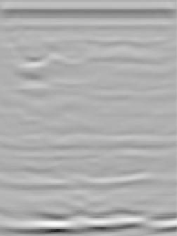
fIGURe 25.8
Migrated radargrams 3 (a) and 13 h (b) after onset of irrigation (top) and NMRA distribution
(bottom) in two depth intervals: 30 to 40 cm (thin line) and 120 to 130 cm (bold line).
(2002) in a numerical experiment. In this case, the method was used to evaluate possible soil water
content variations in two soil depths (35 and 125 cm) 3 and 13 h after onset of irrigation. The analy-
sis was not meant to directly derive absolute soil water content values but to reveal soil moisture
heterogeneities in space. Figure 25.8a and Figure 25.8b show the migrated radargrams (conver-
sion of the travel time axis to distance) and the computed NMRA at two depths over the irrigated
transect. Three hours after onset of irrigation, the highest values occurred on the left-hand side of