Geoscience Reference
In-Depth Information
40.8850
40.8850
6000
5750
5500
5250
5000
4750
4500
4250
4000
3750
3500
3250
3000
2750
2500
2250
2000
60
40.8845
40.8845
58
N
40.8840
40.8840
56
54
40.8835
40.8835
52
40.8830
40.8830
50
40.8825
40.8825
48
46
40.8820
40.8820
44
40.8815
40.8815
42
40
-84.5678 -84.5675 -84.5672
Longitude
-84.5678 -84.5675 -84.5672
Longitude
(a)
(b)
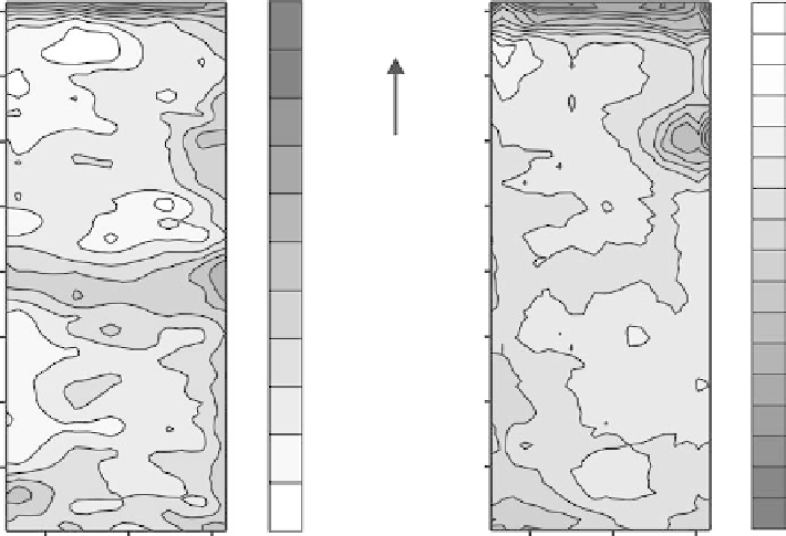
fIGURe 1.2
Soil electrical conductivity and crop yield comparison for a 3 ha field in northwest Ohio:
(a) apparent soil electrical conductivity map obtained with a Veris 3100 Soil EC Mapping System (values are
in millisiemens/meter) and (b) soybean yield map (values are in kilograms/hectare).
differences. These field zones can then be separately managed in an effective and efficient manner
so as to maximize economic benefits while protecting the environment.
McCorkle (1931) conducted one of the first agricultural geophysics studies that focused on the
use of resistivity methods to determine the soil gravimetric water content. There have been a num-
ber of research investigations since that have quantified the bulk soil volumetric water content (θ)
level in soil using EC
a
measured with resistivity or electromagnetic induction methods. There are,
however, certain drawbacks regarding the use of resistivity and electromagnetic induction methods
to determine θ. One drawback is that soil properties in which affect EC
a
differ from one location to
the next, and as a consequence, the EC
a
versus θ relationship must be developed at each particular
field site. In addition, temperature effects on EC
a
values need to be taken into account before accu-
rate θ estimates can be obtained.
GPR has recently proven to be an effective tool for rapidly measuring soil volumetric water con-
tent (θ) over large areas (Grote et al., 2003; Huisman et al., 2003; Lunt et al., 2005). The GPR meth-
ods employed for θ measurement are all based on the determination of a soil's dielectric constant,
also called the relative permittivity (ε
r
). The value of ε
r
is strongly correlated to θ. For mapping θ, a
couple of approaches are used to determine a soil's ε
r
value. One approach is to calculate ε
r
directly
from the radar signal velocity in a soil. The soil radar signal velocity is easily computed by dividing
the length of the direct or reflected signal travel path through the soil by the elapsed time taken by
the signal to travel along the path from the transmitting antenna to the receiving antenna (velocity
equals distance divided by time). The second approach involves positioning the transmitting and
receiving antennas a short distance above the ground surface and then measuring the reflection
coefficient at the ground surface. The reflection coefficient in this case equals the ratio of the radar
signal amplitude reflected from the ground surface to the radar signal amplitude incident at the
ground surface. With the ε
r
of air known (equal to 1), the ε
r
at the soil surface can be calculated