Geoscience Reference
In-Depth Information
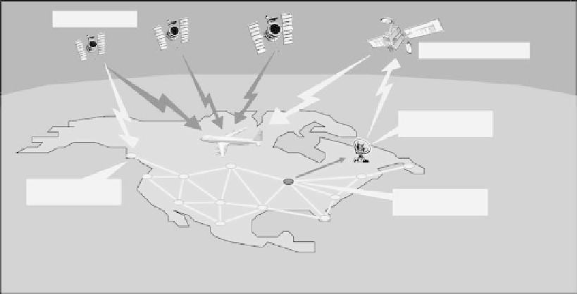
GPS satellite
Geostationary satellite
Ground Earth
station
WA AS reference
station
WA AS master
station
fIGURe 9.12
The Wide Area Augmentation System.
Real_Time_Aspects/TUAM1_Muellerschoen_1.pdf). The satellite uplink message contains GPS
differential corrections and GPS satellite health status data. The positioning accuracy of WADGPS
ranges from submeter to a few meters, depending on the provider, coverage, number of stations
used, error modeling technique, and so forth. DGPS services routinely support the following appli-
cations: land survey, offshore positioning, precision agriculture, aerial photogrammetry and LiDAR
(light detection and ranging), GIS and asset mapping, machine control, aircraft navigation, and
intelligent vehicle highway system (IVHS).
The fundamental concept of WADGPS is the categorization of error sources in the GPS observ-
ables. By constructing a model for each error source (e.g., satellite clock, satellite ephemeris, iono-
spheric delay, and local errors, such as tropospheric delay, multipath, receiver noise, and hardware
bias), the system creates a vector correction. This is the distinction between wide area and local
area differential corrections. Local area augmentation systems transmit a scalar correction from
the reference station to the user for each pseudorange measurement. In contrast, wide area systems
transmit the error models to the user, which are then recombined to form a correction for each
pseudorange measurement. The benefit of the vector correction is its improved ability to capture the
spatial decorrelation of the error sources (http://waas.stanford.edu/tour.html).
9.7.2.1
dGpS Services: examples
GSBAS, such as OmniSTAR™ (www.omnistar.com) and StarFire™ (www.navcomtech.com/
starfire/), are examples of commercial DGPS suppliers, providing worldwide coverage at the sub-
meter to decimeter-level accuracy. For example, the StarFire™ solution represents an advance from
the ground-based augmentation systems because it considers each of the GPS satellite signal error
sources independently, instead of measuring a total (combined) error or atmospheric error only in
the GPS pseudoranges. Examples of government-supported DGPS services include Federal Avia-
tion Administration (FAA)-supported satellite-based Wide Area Augmentation System (WAAS),
ground-based DGPS services, referred to as Local Area DGPS (LADGPS), such as U.S. Coast
Guard and Canadian Coast Guard services, or FAA-supported Local Area Augmentation System
(LAAS). An example of Internet-based WADGPS is the Global Differential GPS (IGDG) pro-
vided by NASA JPL, based on the NASA Global GPS Network (GGN) consisting of approximately
sixty sites (http://gipsy.jpl.nasa.gov/igdg/). IGDG is designed for dual-frequency users and offers 10
cm horizontal and 20 cm vertical real-time positioning accuracy.