Geoscience Reference
In-Depth Information
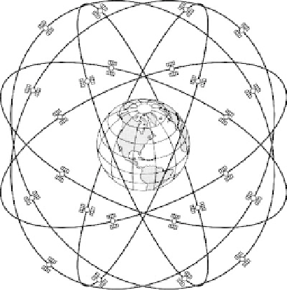
fIGURe 9.2
The Global Positioning System (GPS) constellation. (From Rizos, C., in
Manual of Geospatial
Science and Technology
, pp. 75-94, Taylor & Francis, London, 2002. With permission.)
Earth-Centered-Earth-Fixed (ECEF) reference frame, known as the World Geodetic System 1984
(WGS84) (www.wgs84.com). The clock parameters are provided in the form of polynomial coef-
ficients and, together with the predicted ephemeris, are broadcast to the users in the GPS navigation
message. The accuracy of the predicted orbit is typically several meters.
Since the launch of the first GPS Block I satellite in 1978, the system evolved through sev-
eral spacecraft designs, focused primarily on increased design life, extended autonomous operation
time, better frequency standards (clocks), and the provision for accuracy manipulation, and was
controlled by the DOD. The current constellation, as of February 2008, consists of 31 Block II/
IIA/IIR/IIR-M satellites. Information about the current status of the constellation can be found, for
example, at the U.S. Naval Observatory (USNO) Web site (http://tycho.usno.navy.mil/gpscurr.html).
The
User Segment
, including all GPS equipment used in a variety of civilian and military applica-
tions, establishes the third component of the GPS system (Figure 9.3).
9.4 GpS SIGnAl ChARACteRIStICS
GPS satellites transmit low-power radio signals on two carrier frequencies designated as L1 and
L2. The L1 carrier is 1575.42 MHz, and the L2 carrier is 1227.60 MHz in the ultrahigh frequency
(UHF) band. GPS is a line-of-sight (LOS) system, and thus the signals can penetrate clouds, glass,
and plastic but will not go through most solid objects, such as buildings and dense foliage. A GPS
signal contains three different types of information: a Pseudo-Random Noise (PRN) code, ephem-
eris data (navigation message), and almanac data. The coarse-acquisition (C/A) code is available
on the L1 frequency and the precise (P) code is available on both L1 and L2 signal. Due to the
spread spectrum characteristic of the signals, the system provides a large margin of resistance to
interference. All signals transmitted by GPS satellites are coherently derived from a fundamental
frequency of 10.23 MHz as shown in Table 9.1.
Each satellite transmits a C/A-code and a unique segment of a P-code, which is the satellite's
designated identification (ID), ranging from 1 to 32. This carrier modulation enables the measure-
ment of the signal travel time between the satellite and the receiver (user), which is converted to
pseudorange
(i.e., raw distance between the satellite and the receiver, see Sections 9.6 and 9.7). The
travel time, and thus the pseudorange, measured using the P code is up to ten times more accurate