Geoscience Reference
In-Depth Information
a
81° 00´
Gold occurences
Geology
Nipissing sills
Basalt
Huronian clastics
Diorite
Ultramafics
Mafic volcanics
Tuffs, breccias
Granite
Felsic volcanics
Tonalite
Wacke
80° 30´
47° 45´
47°30´
N
84°
82°
80°
STUDY
AREA
48°
Ontario
0
20
40
47°
Kilometers
40 km
Lake Huron
46°
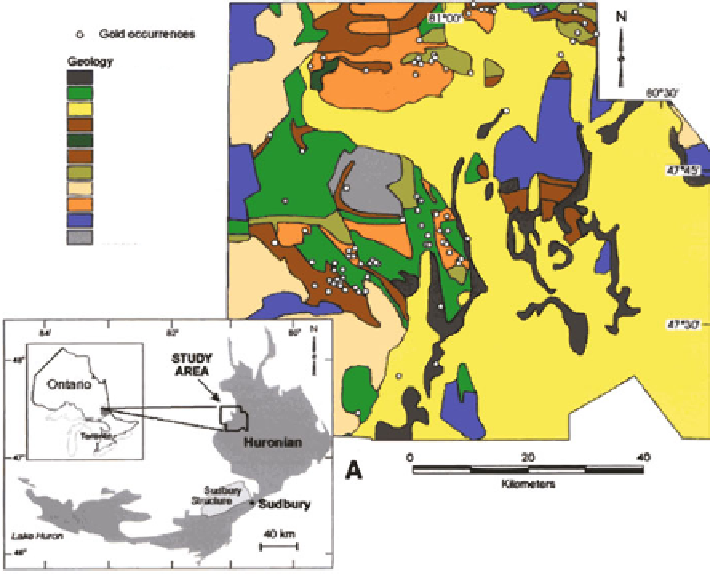
Fig. 5.24
(
a
) Gowganda area, east-central Ontario. Locations of 80 gold occurrences in relation
to bedrock geology; (
b
) third principal component (PC3) of lake geochemistry data, and
(
c
) aeromagnetics (Source: Agterberg and Bonham-Carter
2005
, Fig. 1)
Normally, a sample of geoscientific data compiled for one area is not represen-
tative of another area, especially if some suitable form of discretization is not used.
Because of strong spatial variability, patterns including geophysical and geochem-
ical contour maps differ from place to place not only locally but also at regional
scales. Discretization by reduction of these patterns to binary or ternary form often
helps to prevent adverse effects on mineral potential mapping resulting from
regional variability. This positive aspect of discretization, which is not necessarily
restricted to WofE, will be illustrated in this section by geographically separating
training areas from testing areas in Experiments 3-5.
Location and patterns for gold deposits, geology, geochemistry and aeromag-
netics of the study area are shown in Fig.
5.24
. These map patterns were used as
input in the experiments. On the generalized geological map it can be seen that the
80 gold occurrences are spatially associated with felsic and mafic metavolcanics,
which were selected to form the binary map pattern for bedrock geology.
Figure
5.24a
is for the third principal component (PC3) derived from
geochemical elements for lake sediments in the area (original data obtained from
the Ontario Geological Survey “Treasure Hunt” database). PC3 is primarily deter-
mined by Cd, Zn, Mo, Br, Cu and Pb concentration values. Its pattern shows


Search WWH ::

Custom Search