Geoscience Reference
In-Depth Information
1
27
28
26
2
24
25
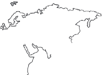
24 Volga
25 Ob
26 Yeni-sei
27 Lena
28 Amur
29 Hwang-ho
30 Yangtse
31 Mekong
10
11
3
10 Rhine
11 Danube
4
22
29
5
6
21
30
12 Senegal
13 Volta
14 Niger
12
23
14
15
31
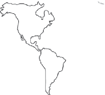
1 Yukon
2 Mackenzie
3 St Lawrence
4 Mississippi
5 Colorado
6 Rio Grande
7 Orinoco
8 Amazon
9 Parana
16
7
13
17
21 Tigris-
Euphrates
22 Indus
23 Ganges
8
18
1
9
15 Lake Chad
16 Nile
17 Congo
18 Zambezi
19 Okavango
20 Orange
9
20
CLIMATE ZONES
Polar
Humid
Tropical
Dry
Fig. 3.1
Climatic zones and the world's
largest river basins. (Based on Newson
1992, fig. 4.1. Climate zones from
The Times Atlas of the World
1983.)
Table 3.1
Transport of sedimentary material from continents to oceans. (Based on Knighton (1998), with data from Degens et al.
(1991), Meybeck (1979), Milliman & Meade (1983) and Walling (1987).)
Continent
Land area
Mean annual runoff
Total annual suspended
(10
6
km
2
)
(10
3
km
3
)
sediment load (10
6
tyr
−
1
)
Africa
15.3
3.4
530
Asia
28.1
12.2
6433
Europe
4.6
2.8
230
North and Central America
17.5
7.8
1462
Oceania and Pacific Islands
5.2
2.4
3062
South America
17.9
11.0
1788
amounts determined by climate (precipitation),
topography, vegetation cover, land-use, and the
susceptibility of the underlying rocks, soils or
other unconsolidated materials to physical, chem-
ical and biological weathering.
A river system is, by definition, the system of
connected river channels in a drainage (catchment)
basin (Bridge 2003). The system contains a large
number of features, but the two most important
are its channels and floodplains (Fig. 3.2). In
the upland, mountainous parts of river basins,
relief is relatively high, channels are incised into
bedrock or alluvium, and floodplains tend to
be narrow. For a more detailed discussion of
sedimentology in mountainous environments,
the reader is directed to Chapter 2. In the middle
to lowland portions of river systems, relief is
lower, valleys are broad and larger-scale flood-
plains are developed. From a sedimentological
perspective, rivers are often classified according
to their planform channel geometries, with four
major types traditionally defined: (i) straight,
(ii) meandering, (iii) braided and (iv) anastomos-
ing (Fig. 3.3). This classification has been seen as
flawed, mainly because the classes overlap. As a
result, authors such as Rust (1978) and Bristow
(1996) have suggested that these types should
not be viewed as separate entities but, rather, as
end members of a cyclical continuum (Fig. 3.4).
Modifications from one end member to another
can be a result of changes in sinuosity (river
length divided by valley length) and the amount
of braiding (channel length divided by valley
length or island length divided by river length).
For example, straight rivers can metamorphose
into meandering rivers by an increase in sinuos-
ity, and meandering rivers can change into
braided rivers through the development of bars