Geoscience Reference
In-Depth Information
(a)
(b)
2.0
B
V
F103
SWI T Z ERL A ND
SWITZERLAND
1.5
1.0
F104
W 4505 m
D 4545 m
R
A 4027 m
0.5
F102
N
F116
F101
4478
0
0
km
10
MR 4634 m
15
20
25
30
5
10
15
April
May
(c)
(d)
SE
NW
2200 m
Rock fall 9.5.91
Paragneiss
2000 m
1800 m
Rock fall 18.4.91
Orthogneiss
1600 m
Basal fault
Deposit
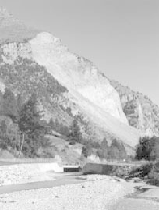
Fig. 2.12
Randa rock slide. (a) Location map showing position of the Mattertal valley, south-western Switzerland (MR, Monte Rosa;
A, Allalinhorn; D, Dom; R, Randa; W, Weisshorn; V, Visp; B, Brig). (b) Records of heights of displacement based on geodetic
measurements taken in the central part of the sliding rock mass (Source: Götz & Zimmermann 1993). F101, etc., refer to specific
monitoring locations on the slide. (Reproduced with permission of The Japan Landslide Society.) (c) Photograph of the Randa rock slide
in 2003. The entrance to the River Vispa bypass tunnel is shown in the foreground. (Photograph courtesy of R.M. Johnson.) (d) Cross-
section through the rock face and rock slide deposits. (Source: Quanterra 2003.)
measurements indicated an accelerated motion
of the rock mass (Götz & Zimmermann 1993)
(Fig. 2.12b). During the evening of 9 May 10
resulting in 30 houses being flooded. Dust was
deposited to a depth of 10 - 40 cm in a 1 km
radius around the slide area and some local
housing was buried in debris up to 60 m deep
(Götz & Zimmermann 1993).
Formation of the rockslide-dammed lake in
the valley posed two major hazards: local flood-
ing and a sudden dam break flood downstream.
Remedial measures were taken to keep lake levels
×
10
6
m
3
of rock was deposited in a series of slides
(generally
10
6
m
3
) over a period of 7 hours.
Deposits covered approximately 0.8 km of the
Zermatt-Rhône Valley railway line and about
0.2 km of the main road. The deposit caused
a rock-slide dam across the Vispa River
<
1
×