Geoscience Reference
In-Depth Information
Degraded side slope
of former river valley
Degraded
debris slide
High altitude glacial
and periglacial
1
Boulder field
Rock face
with rockfall
Talus / scree
Taluvium
Colluvium
Tributary
valley
Ancient high level
terrace or
erosion surface
2
Active lower slopes
2
Colluvium
3
Principal
valley
4
Residual soil or
weathered rock
4
3
5
4
Braided
channel with
bar deposits
Floodplain
deposits
Rotational
slide
5
Fan
Alluvium
Incised gully
Debris slide
Taluvium cover to
weathered bedrock
Rapids
Rock slope
Young river
terrace deposits
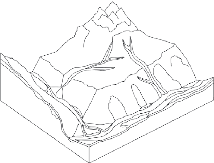
Fig. 2.5
Land-system diagram of a high-mountain environment showing five major terrain zones: (1) high-altitude glacial and
periglacial; (2) free rock faces and debris slopes; (3) degraded middle slopes and ancient valley floors; (4) active lower slopes; and
(5) valley floors. (Redrawn from
Engineering Geology
, Fookes, P.G., Sweeney, H., Manby, C.N.D. & Martin, R.P. (1985) Geological and
geotechnical engineering aspects of low cost roads in mountainous terrain,
21
, 1-152, with permission from Elsevier.)
understanding can be achieved if the landform
associations in mountainous terrain can be shown
in a land-systems model. Fookes et al. (1985)
have developed such a model based on east Nepal,
but as Gerrard (1990) argues, this model is more
generally applicable to most extratropical high
mountains that have been extensively glaciated.
Figure 2.5 shows this model and the interrela-
tionship between five main zones: high-altitude
glacial and periglacial; free rock faces and debris
slopes; degraded midslopes and ancient valley
floors; active lower slopes; and valley floors.
The model is most useful in demonstrating the
coupling between the slope sediment systems and
valley sediment systems that actively occur in
high mountain environments and which form the
basis of conceptual models of sediment delivery
(e.g. Fig. 2.4; Caine 1974; Barsch & Caine 1984).
Given these different geomorphological subsys-
tems there is an enormous variety of processes
operating in mountain environments. However,
in terms of environmental sedimentology the
most significant are usually the destructive mass
movements which generally occur in mountain
torrents or on steep unstable bedrock slopes.
In terms of the fluvial system as a whole
headwater mountain catchments are viewed
as sediment production zones feeding bedload
and suspended sediment downstream. A simple
schematic model describing the linkages between
mountain catchments and variations in fluvial
form along the river profile from the headwaters