Geoscience Reference
In-Depth Information
II
III
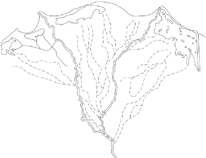
LSD predominantly easterly
Mediterranean
Sea
4
2
I
3
1
A
A
A
B
S
B
F
N
0
50km
Water Quality
S = Salt
B = Brackish
F = Fresh
Sand barrier
Former distributaries
Cairo
See table for descriptons for letters, numbers
and roman numerals
Marshland
Erosional sectors
Site
Erosion rate (m yr
−
1
)
Measurement period
Reference
1
>50
1909 to late twentieth century
Stanley & Warne (1998)
>100
1971 to mid-1990s
Frihy (1996)
113
1985-1991
White & El Asmar (1999)
52-88*
1971-1990
Frihy et al. (2002)
3-13†
1990-2000
Frihy et al. (2002)
118.6
1984-2000
Ahmed (2002)
18-230
Last century
Ahmed (2002)
2
Unspecified
1909 to late twentieth century
Stanley & Warne (1998)
10
1909 to mid-1990s
Frihy (1996)
10
1971-1990
Frihy et al. (2002)
15
1984-1991
White & El Asmar (1999)
3
6.5
1971 to mid-1990s
Frihy (1996)
1.3
1909-1989
El-Fishawi (1994)
2.1
1984-1991
White & El Asmar (1999)
4
6.5
1971 to mid-1990s
Frihy (1996)
3.8
1909-1989
El-Fishawi (1994)
5.0
1984-1991
White & El Asmar (1999)
*Pre-defence construction in 1990. First figure to west of promontory, second to east.
†Post-defence construction. First figure to west of promontory, second to east.
Accretional sectors
Site
Accretion rate (m yr
−
1
)
Measurement period
Reference
A
Up to 13
1971 to mid-1990s
Frihy (1996)
14
1971-1990
Frihy et al. (2002)
B
Unspecified
1909 to late twentieth century
Stanley & Warne (1998)
Offshore sediment transport
Site
To offshore (m
3
yr
−
1
)
Measurement period
Reference
3.2
×
10
6
I
Current
McManus (2002)
1.48
×
10
6
II
Current
McManus (2002)
1.8
×
10
6
III
current
McManus (2002)
Case Fig. 7.2
The Nile delta showing areas of erosion and accretion: LSD, longshore drift. (Modified from Carter 1988, p. 483.)