Geoscience Reference
In-Depth Information
(a)
Zone of conversion
of terrestrial to
aquatic habits
MHWS'
MHWS
S.L.R
Migration of
high water mark
landwards
df
low
df
int
df
mid
df
low
df
int
df
mid
Post-S.L.R
Transition
communities
High
marsh
Mid-
marsh
Low
marsh
Intertidal
mudflats
Pre-S.L.R
Marsh
edge
High water mark
fixed at embankment
(b)
Loss of high marsh
and upper mid-marsh
MHWS'
MHWS
S.L.R
df
low
df
mid
df
low
df
int
df
int
Post-S.L.R
High
marsh
Mid
marsh
Low
marsh
Intertidal
mudflats
Pre-S.L.R
Terrestrial
Embankment
Marsh
edge
= lost marsh areas
MHWS = Mean High Water of Spring Tides
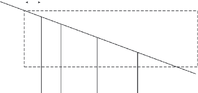
Fig. 7.13
Impacts of sea-level rise on estuarine intertidal zonation. (a) No landward constraints allow a gradual shift in intertidal zones
and maintenance of vegetation community succession. (b) The sea wall to landwards results in coastal squeeze and loss of habitats.
(Modified from French 2001, p. 278.)
that can tolerate only short or periodic inunda-
tion occur on the highest marsh. Figure 7.13a
shows an idealized section across a marsh with
low, mid- and high marsh communities. In a
simplistic sense, low marsh vegetation is stable
between the depth (d) and inundation fre-
quencies (f ) depicted by df
Int
, df
Low
, where df
Int
represents the upper limit of the intertidal mud-
flat and df
Low
represents the upper limit of the
low marsh. Similarly, the mid-marsh commu-
nities are stable between df
Low
and df
Mid
, where
df
Mid
represents the upper limit of the mid-marsh.
Landward of this point, higher marsh and transi-
tional communities dominate. Under conditions