Geoscience Reference
In-Depth Information
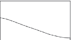
(a) Well stratified (salt wedge)
Fresh
Fresh
Mixing
Salt
Salt
Salinity
e.g. Mississippi
Low
High
(b) Partially mixed
Fresh
Fresh
Brackish
Salt
Salt
Salinity
e.g. Mersey / Thames
Low
High
(c) Well mixed
Brackish
Fig. 7.1
The classification of estuaries
based on the mixing of fresh- and
saltwater bodies. (Modified from various
sources.)
e.g. Severn
Salinity
Low
High
of between 2 and 4 m, mesotidal, and those
above 4 m, macrotidal (Pethick 1984). Given
that many estuaries have tidal ranges in excess
of 4 m, the earlier classification of Davies (1964)
classes macrotidal estuaries as being those with
a tidal range between 4 and 6 m, whereas ranges
in excess of this are known as hypertidal.
Although both systems are in use, it is important
when referring to a macrotidal system to make
reference to which system is being used. A more
complicated, but more useful system classifies
estuaries on the basis of the amount of mixing
that occurs between salt water and fresh water.
Salt water is denser than fresh water, and so in a
low-energy estuary there is a tendency for the
fresh water to flow over the salt water, the two
bodies of water maintaining their integrity, with
the saltwater component forming a 'wedge' below
the fresh (Fig. 7.1a). This is a salt wedge, or well-
stratified estuary. A typical profile will show
that with increasing depth, the water will stay
generally fresh, then rapidly increase in salinity.
Bearing in mind the importance of salt and fresh-
water mixing for the deposition of clays, the
only place where this will occur is where the salt
wedge meets the fresh water. Clearly, as the tide
comes in and goes out, this point will move up
and down the estuary, but regardless of where it
is, it is marked by an area of higher turbidity
caused by flocculated clays settling out (see sec-
tion 7.2.2). This is called the turbidity maximum.
As tidal range and energy increase, the
increased turbulence causes greater mixing of
the fresh- and saltwater bodies. In a partially
mixed estuary, there is still an identifiable salt-
and freshwater layer but the boundary between