Geoscience Reference
In-Depth Information
10
3
10
2
Humid
Semi-arid
Arid
Hyper-arid
10
1
10
−
2
10
−
1
10
2
Drainage area (km
2
)
10
3
10
4
10
5
10
6
10
7
1
10
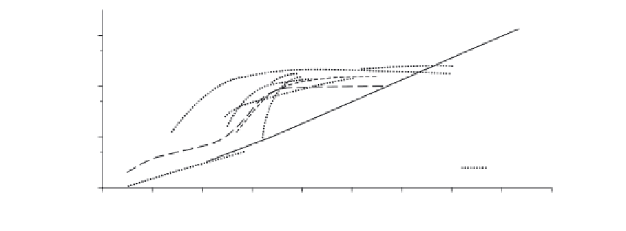
Fig. 5.6
The relationship between bankfull width and drainage area under different climatic environments. (After Wolman &
Gerson 1978.)
the outer channel. Successively more frequent,
lower magnitude floods occupy the topogra-
phically lower and narrower parts of the river
channel (Fig. 5.7). Burkham (1972) recorded
changes in river width over a series of floods
in the Gila River, Arizona (Fig. 5.8). The largest
of these floods had a recurrence interval of 300
years and increased channel width by 600%.
Recovery here took some 50 years, but in more
arid areas it can take much longer for vegetation
to re-establish itself. Thus relationships based
on bankfull discharge (considered the dominant
channel forming discharge in perennial rivers by
many authors) are of less relevance to ephemeral
arid river systems.
One of the main differences between peren-
nial and ephemeral river systems is in the pro-
pagation of the flood wave. For the reasons
discussed above, the flood wave will be highly
variable as each rainstorm event potentially
activates a different area of the catchment.
Also the small size of the rain cells (
systems activated in around 20 minutes but main
tributaries may take hours, depending on the
scale of the system. Schick (1988) suggests a pig-
gyback contribution of individual tributaries
generates the multipeak appearance of many arid
flash floods. This spatial difference in rainfall
may be increased where topographic variance
is maximized; for example, in basin and range
style topographies.
The flash-flood hydrograph is dominated by a
steep rising limb. Normally the first observation
is a flood bore. These vary in height. Hassan
(1990) reported flood bores of 4 - 40 cm in
height, and moving at 0.2-1 m s
−1
, with velo-
city increasing with bore height. It is notable in
gravel-bed rivers, however, that preceding the
surface bore is a subsurface percolation of water
through the river-bed coarse material. Flood
bores can arrive suddenly and wreak devastation
(Hjalmarson 1984) as they are rapidly followed
by the flood peak within 10 -23 minutes (Renard
& Keppel 1966; Schick 1970; Reid & Frostick
1987). The flood peak often consists of several
spikes reflecting the temporal and spatial activa-
tion of tributaries within the system (Fig. 5.9).
Within a few minutes of the bore average stream
velocities may have risen to 3 m s
−1
, and water-
stage height has been reported to rise by 0.25 m
min
−1
(Reid et al. 1994). The resulting flood
may last only a few hours. This is a function of
the lack of sustaining rainfall and thus surface
runoff, combined with a lack of subsurface flow
14 km),
typically distributed 40 - 60 km apart (Sharon
1974), means that for increasingly larger basins
a smaller percentage of the catchment will remain
active, unless the region receives rainfall from
larger weather systems (e.g. Australia already
discussed). In addition to this the rain cells will
migrate as they precipitate. Thus, tributaries
within catchments may be activated at different
times. Runoff generation typically takes only
a few minutes in arid environments, with gully
<