Geoscience Reference
In-Depth Information
(a)
350
A. Petit Rhône River
300
1895
250
200
150
100
1995
50
0
40 45 50 55
Distance from the sea (km)
700
B. Grand Rhône River
600
1907
500
400
300
200
1999
100
0
5 10 15 20 25 30 35 40
Distance from the sea (km)
(c)
(b)
Q
−
, Qs
+
Q
+
, Qs
−
21
Sand-bed reaches
Sand-bed reaches
17
13
avulsion
1936
1954
1978
Gravel-bed reaches
sinuosity
−
, slope
+
9
Q
+
Q
+
large flood
5
Gravel-bed reaches
950
1000
1050
1100
1150
1200
1250
Progressive distance from datum (m)
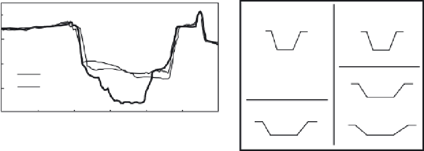
Fig. 3.17
(a) Changes in channel width in the Petit Rhône River (A) and the Grand Rhône River (B) between 1895 and 1999. Both
graphs highlight the channel narrowing as a result of channelization at the end of the nineteenth century. (After Arnauld-Fassetta 2003.)
(b) Channel incision along the Arno River in the Lower Valdarno-Pisa Plain, Italy, showing typical change in cross-section, with limited
bed lowering from 1936 to 1954, and intense incision from 1954 to 1978. (Based on fig. 2 of Surian & Rinaldi 2003.) (c) Summary of
adjustments in sand-bed and gravel-bed reaches of the lower Duchesne River, Utah, USA, owing to the creation of large-scale diversions
and increased water withdrawal for irrigation. Bold arrows indicate the primary adjustment to changes in discharge (
Q
) and fine
sediment supply (
Q
s
), and thin arrows indicate second-order adjustments.
Q
+
indicates an increase in gravel-sized sediment derived
from lateral erosion. (After Gaeuman et al. 2005, fig. 15.)
irrigation during the early part of the twentieth
century in the Duchesne River basin, Utah, caused
local gully erosion and subsequent downstream
delivery of fine sediment, which in turn led to
filling of secondary channels, the narrowing of the
main channel and transformation of a narrow
sand-bed channel into a braided gravel-bed reach
(Fig. 3.17c).