Geoscience Reference
In-Depth Information
it would be wrong to think that all groundwater
moves slowly; it is common to see substantial move-
ment of the water and regular replenishment during
wetter months. In limestone areas the groundwater
can move as underground rivers, although it may
take a long time for the water to reach these con-
duits. In terms of surface hydrology groundwater
plays an important part in sustaining streamflows
during summer months.
The terminology surrounding groundwater is
considerable and will not be covered in any great
depth here. The emphasis is on explaining the
major areas of groundwater hydrology without great
detail. There are numerous texts dealing with
groundwater hydrology as a separate subject, e.g.
Freeze and Cherry (1979) and Price (1996).
Wetting
Drying
Soil moisture
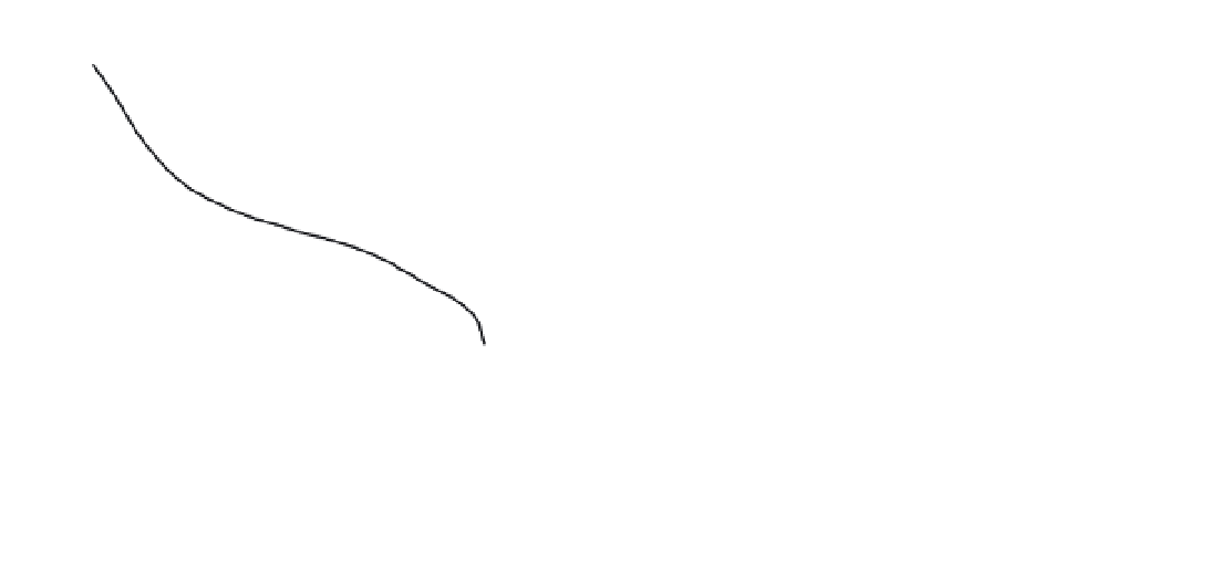
Figure 4.4
A generalised suction-moisture (or soil
characteristic) curve for a soil. The two lines show the
difference in measurements obtained through a wetting
or drying measurement route (hysteresis).
Aquifers and aquitards
conductivity value for a given soil moisture (Klute,
1986).
There is a major problem in interpreting suction-
moisture curves, namely
hysteresis
. In short, the
water content at a given soil suction depends on
whether the soil is being wetted or dried. There is
a different shaped curve for wetting soils than for
drying ones, a fact that can be related to the way
that water enters and leaves pores. It takes a larger
force for air to exit a narrow pore neck (e.g. when it
is drying out) than for water to enter (wetting). Care
must be taken in interpreting a suction-moisture
curve, as the method of measurement may have a
large influence on the overall shape.
An
aquifer
is a layer of unconsolidated or consoli-
dated rock that is able to transmit and store enough
water for extraction. Aquifers range in geology from
unconsolidated gravels such as the Ogallala aquifer
in the USA (see Chapter 8) to distinct geological
formations (e.g. chalk underlying London and much
of south-east England). An
aquitard
is a geological
formation that transmits water at a much slower
rate than the aquifer. This is an oddly loose defi-
nition, but reflects the fact that an aquitard only
becomes so relative to an aquifer. To borrow from a
popular aphorism, 'one man's aquifer is another
man's aquitard'. The aquitard becomes so because it
is confining the flow over an aquifer. In another place
the same geological formation may be considered
an aquifer. The term
aquifuge
is sometimes used
to refer to a totally impermeable rock formation (i.e.
it could never be considered an aquifer).
There are two forms of aquifer that can be seen:
confined and unconfined. A
confined aquifer
has a
flow boundary (aquitard) above and below it that
constricts the flow of water into a confined area (see
Figure 4.5). Geological formations are the most
common form of confined aquifers, and as they often
occur as layers the flow of water is restricted in the
vertical dimension but not in the horizontal. Water
Water in the saturated zone
Once water has infiltrated through the unsaturated
zone it reaches the water table and becomes ground-
water. This water moves slowly and is not available
for evaporation (except through transpiration in
deep-rooted plants), consequently it has a long
residence time. This may be so long as to provide
groundwater reserves available from more pluvial
(i.e. greater precipitation) times. This can be seen
in the Middle East where Saudi Arabia is able to
draw on extensive 'fossil water' reserves. However,