Geoscience Reference
In-Depth Information
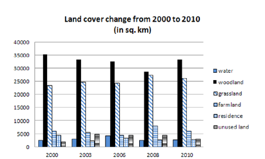
Fig. 6. The areas of each land cover type and its change from 2000 to 2010
5. Discussion and conclusion
In this study, MODIS L1B data with 250 m resolution were used to monitor the RD change
in western Guangxi from 2000 to 2010. Two methods of NDVI calculation and supervised
classification were performed to detect the RD extent.
From the above results, the distribution of RD areas extended from 2000 to 2008 and
reduced from 2008 to 2010. The first method is based on the relationships between NDVI
and RD. In general, if NDVI values of a region are high, it means the vegetation cover is
well protected with a rare extent of RD. Otherwise the lower of the NDVI, the more
serious of RD. Based on this assumption, the RD extent was determined in the study area
from 2000 to 2010.
However, the RD areas were not only identified by NDVI. Some other factors may also
affect the RD extent which can be extracted from MODIS data. To compare the RD extent
with the change of land cover types, supervised classification was performed to determine
six types of land cover in the study area (see Fig. 5). With the reference of previous studies
of local land cover types (Li et al., 2006; Nong, 2007) and the yearbooks of Guangxi, the
training sites and samples of six classes were selected and determined. Although there are
misclassification errors involved, the results of image classification are reasonable to agree
well with the previous results of land cover types and the statistic data in the yearbooks of
Guangxi. Comparatively, the NDVI calculation is better and easier to be utilized to detect
the RD extent than image classification in the study area.
It is reported that 37.6% RD is resulted from natural factors, while 62.4% of the RD area is
caused by direct human activities (Nong, 2007). In this study, the natural factors may
include:
Search WWH ::

Custom Search