Geoscience Reference
In-Depth Information
Separate lithology rules are used for each depositional sequence with up to two variograms
to controlling different directions and scales. Petrophysical Property Modeling populates
facies models with petrophysical properties (porosity, permeability, water saturation,
etc.
)
by interval and constrained by facies. The DecisionSpace
Desktop Earth Modeling uses the
Turning Bands algorithm as the simulation method with Collocated CoSimulation as one of
the options. Kriging and Collocated CoKriging are additional geostatistical algorithms
available. Collocated CoKriging is a variation of the classical kriging interpolation, where
the variogram is computed from a secondary variable that serves as an additional spatial
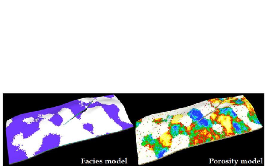
constraint. Fig. 7, gives an example of facies model realization and facies-constrained model
of porosity distribution.
Fig. 7.
An example of facies model realization (sand fraction in white, shale fraction in blue)
and facies-constrained model of porosity distribution of Brugge synthetic model (Peters e
t
al.
, 2009), generated by DecisionSpace
Desktop Earth Modeling.
2.4 Novel concepts in local continuity modeling
Traditional reservoir modeling techniques use simplified
two-point statistics
to describe the
pattern of spatial variation in geological properties. Such techniques implement a
variogram
model that quantifies the average of expected variability as a function of
distance
and
direction
. In reservoirs, where the geological characteristics are very continuous and easily
correlated from well to well, the range (or scale) of correlation will be large while in
reservoirs, where the geological characteristics change quickly over short distances, the
correlation scales will be shorter. The later phenomenon is very common in sedimentary
environments, where the primary mechanism of transport during deposition is water,
resulting in highly
channelized
structures (
e.g.
deltaic channels, fluvial deposits, turbidities).
These environments usually demonstrate a large degree of local anisotropy and of
correlation variation between directions along the channel axis and perpendicular to the
channel axis.
Because the principles of conventional (
i.e.
two-point) geostatistical practice still require the
nomination of a
single
(average) direction of maximum continuity its use for modeling
complex sedimentary environments becomes highly challenging if not impossible. Recently,
technology for 3D volumetric modeling of geological properties, using a Maximum
Continuity Field (MCF) (Yarus
et al.
, 2009) has been proposed. The new method represents
geological properties within a volume of the subsurface by distributing a plurality of data
points in the absence of the grid with the notion of geological continuity and directionality
represented by MCF, hence entitled as the Point-Vector (PV) method. It introduces several
game-changing components to the area of geomodeling:
Search WWH ::

Custom Search