Geoscience Reference
In-Depth Information
3.4 Results and Discussion
The analysis of sediment redistribution in the Baltic area using the methods sketched
above is clearly a complex task, and to a considerable degree the validity of the
methods used must be assessed by how geologically reasonable the product is per-
ceived to be. The results of our analysis are described below, first in the areas
peripheral to the Baltic-White Sea lowland and then in the lowland itself.
The Baltic-White Sea lowland (lowland for short) exhibits a regional first-order
bedform that was to a significant degree created by strong diverse and multiphase
glacial and fluvioglacial erosion of pliable sedimentary rocks covering the slope
of Finland to the lakes Ladoga and Onega and then to the White Sea. It seems
to have formed during rapid erosional lowering of wide Tertiary plains with the
progressive removal of saprolites and less stable sediments. Basement features such
as the sub-Cambrian or sub-Upper Vendian peneplains were exhumed around the
A narrow zone of eroded post-Late Vendian cover and Riphean-Jotnian forma-
tions is traced by the deepest indentations of the bedrock surface where hundreds of
meters of unmetamorphosed rocks had been eroded. The deepest parts of the low-
land usually coincide with areas where the sedimentary cover is truncated or, more
rarely, with zones where the most friable sedimentary units thin. Major aquifers are
often involved in the detachment of huge masses of cover. For example, the Gdov
aquifer at the base of Late Vendian cover probably facilitated stripping along zones
of disintegrated sandstone cementation and in areas with deep dissection by tunnel
valleys or glacial hollows.
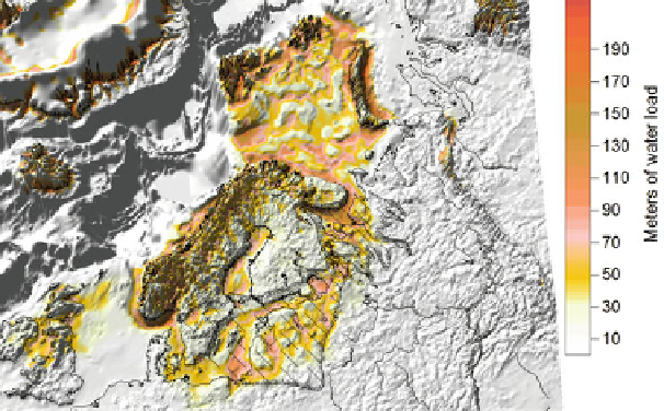
Fig. 3.5
Weischselian net erosion recalculated in meters of water load using averaged rock density.
Baltic-White Sea erosion lowland is marked by slash pattern with half-ticks outline