Geoscience Reference
In-Depth Information
band at 550 nm contains least information about all in-water constituents.
K
d
(490)
is also of special interest from a monitoring point of view, because it has previously
been shown to be the most reliable product that can be derived from remote sensing
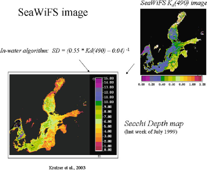
20.9
shows a Secchi depth map of the Baltic Sea derived with SeaWiFS with a 1 km
resolution. Secchi depth and
K
d
(490) correlations were modelled based on in situ
data of the northwestern Baltic, and
K
d
(490) was derived from SeaWiFS data. For
validation purposes, in situ measured Secchi depth data from the open Baltic Sea
and the Gulf of Riga were compared to satellite-derived Secchi depth and showed
Secchi depth from MERIS full resolution data of 300 m using MERIS channels 3
(490 nm) and 6 (620 nm). Figure
20.10
shows the spectral diffuse attenuation coeffi-
cient
K
d
(490) for Himmerfjärden bay and adjacent areas, derived from MERIS full
resolution data. The algorithm was validated with sea-truthing data using another
MERIS scene. The example demonstrates that the data can be used to monitor water
transparency also in coastal areas. This type of information with its synoptic view is
very valid as it cannot be gained from any other technique.
Fig. 20.9
Secchi depth map derived from SeaWiFS diffuse attenuation at 490 nm,
K
d
(490), and a
local in-water algorithm (Kratzer et al.
2003
)
; composite image for the first week of August 1999.
Strictly speaking, the map is only valid in the Baltic proper and/or areas with YS concentrations
similar to those in the northwestern Baltic Sea (as YS is the dominant optical component)