Geoscience Reference
In-Depth Information
In the Neva Bay, about 70% of the northern and southern shores are eroded
and under retreat. The southern coastal zone of the gulf from Lebyazhye to the
St. Petersburg Flood Protection Facility is characterized by very intense coastal
dynamics. According to many observations in the neighborhood of Lebyazhye and
cesses of coast destruction increased relative to previous decades. Intense erosion
took place from 1975-1976 to 1989-1990 according to the analysis of aerial photo.
Sandy beaches were eroded up to 30 m west of Lebyazhye and up to 70 m near
Bolshaya Izhora. The comparison of the air photos from 1989 and recent high-
resolution satellite images reveal that, since 1980, maximal shoreline recession in
some parts of the former sand accretion areas has been more than 90 m up to now
The coastal erosion is also one of the most serious problems of the Kurortny
district of St. Petersburg, which is located along the northern coast of the Gulf of
Finland to the west of St. Petersburg Flood Protection Facility. This area is specif-
ically important as a unique recreation zone of northwest Russia. The analysis of
historical materials, archive of aerial photographs, and modern high-resolution satel-
lite images has shown that the major parts of the coasts are eroded and therefore
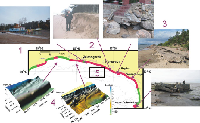
Fig. 16.7
Results of intense coastal zone erosion (the Kurortny district of St. Petersburg, the north-
ern coast of the Gulf of Finland).
Red color
- coastal erosion with rate of shoreline retreat from
0.5 to 2.2 m/year;
green color
- stable and progradating (up to 0.5 m/year) coasts.
1,
erosion of
sandy beaches;
2,
escarp in the coastal dune after the winter surge accompanied by flood (2.25 m
higher than the zero water level), January 11, 2007 (photos by D. Ryabchuk);
3,
destruction of
the coast protecting structures;
4,
erosion of the submarine terrace;
5,
area of submarine terrace
erosion, shown in Fig.
16.9