Geoscience Reference
In-Depth Information
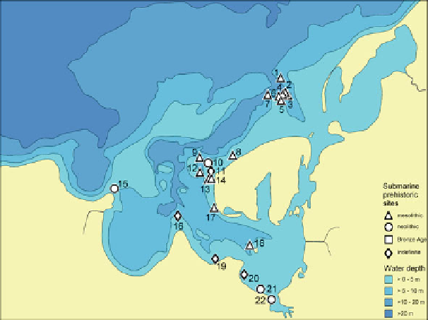
Fig. 15.9
Distribution of submerged Mesolithic and Early Neolithic sites in the Wismar Bight
(after Jöns et al.
2007
, fig. 2)
geophysical and Hyball surveys and, in a second step, partly excavated underwa-
ter. As well as seeking answers to several questions about the settlement pattern
and chronology of the respective sites, a further aim is to gather data about ancient
coastlines and the dynamics of the rise in sea levels.
Of special importance is the Jäckelberg-Huk site, located on the edge of the
Jäckelberg at a depth of 8.5 m below the present sea level, because it is one of
the oldest known submarine sites in the waters of the Wismar Bight. Radiocarbon
analyses date the site to the period between 6,400 and 6,000 cal. BC (Fig.
15.10
).
The fish remains found on the site consist only of pike, perch and eel, which indi-
cate a freshwater environment; the settlement must therefore have been situated in
immediate proximity to a freshwater lake. The salvaged artefacts include trapezes,
rhombic arrowheads and also a few very small longish triangular microliths, which
prove that the people from this settlement were closely related to the initial phase of
the southern Scandinavian Kongemose culture (Sørensen
1996
).
In the same area, the late Mesolithic Jäckelgrund-Orth site was discovered at a
depth of 7-8 m below the present sea level.
14
C dates for tree stumps from this site
indicate that it was occupied from 6,000 to 5,700 cal. BC (Jöns et al.
2007
).
Also of supra-regional importance is the Timmendorf-Nordmole II site. Here,
parts of a fishing fence were excavated at a depth of 5 m below the present sea
level, which had blocked the end of a small brook. The preservation conditions
for organic material on the site were excellent; wooden artefacts such as several
leister prongs and parts of a fish trap were recovered. Analysis of the find material