Geoscience Reference
In-Depth Information
14.4.5 Waves
Waves are the driving force for sediment transport simulation in Sedsim. Here, they
are parameterized by the module WAVE (HEIGHT). This module requires a time
series with significant heights and directions for waves approaching the study area.
The behaviour of the waves adjusted by morphological conditions is calculated in
Sedsim internally, with refraction simulated by the module WAVE REFRACTION.
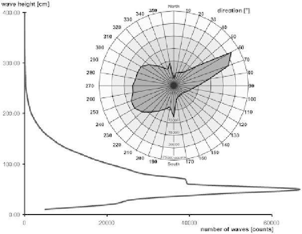
A consistent time series of waves between 1958 and 2002 for the study area is avail-
able, modelled for a gauging station site at 54.69
◦
north, 12.69
◦
east, approximately
27 km to the north of the Zingst peninsula. Data source is the coastDat database,
the waves travel either from the northeast, between 50
◦
and 80
◦
, or from the west,
with a more dispersed orientation between 220
◦
and 300
◦
. This modelled data set
provides values in hourly intervals resulting in a very large data volume. For the
application in Sedsim, the data set was averaged into semi-yearly time slices. The
winter season lasts from October to April, while the summer season covers the rest
of the year. According to the time span to be covered by the modelling (see pre-
vious chapter), a time series for 840 years is required; therefore, the 44-year data
set was prolonged with a simple line-up. Although it seems obvious that waves
will change in the future because of global warming, the linear character of the
Fig. 14.7
Wave statistics for the Darss-Zingst peninsula region.
Data source
: coastDat database