Geoscience Reference
In-Depth Information
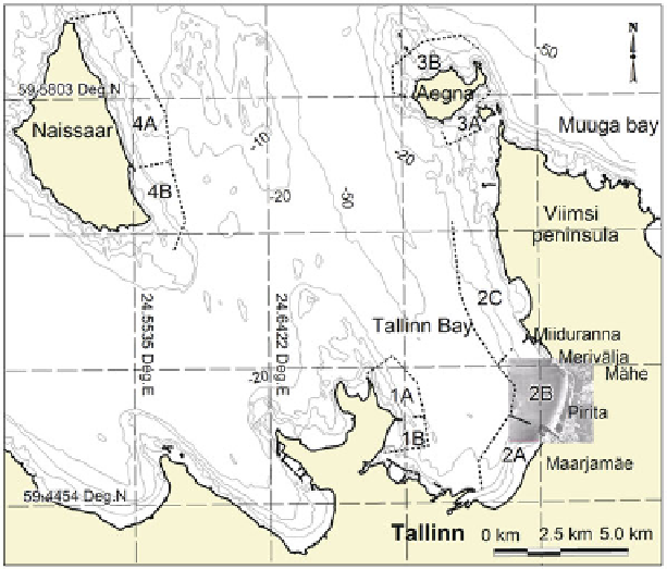
Fig. 13.3
Location scheme of Pirita Beach and adjacent coastal engineering structures.
Dotted
lines
show cells of sediment transport according to Soomere et al.
(
2007
)
: cell 1 along the western
coast of the inner part of Tallinn Bay (divided into subcells 1A and 1B by Katariina jetty); cell 2
along the eastern coast of Tallinn Bay (divided into subcells 2A, 2B, and 2C by Pirita Harbour and
the Port of Miiduranna); cell 3 surrounding the island of Aegna (subcells 3A and 3B at the southern
and northern coasts, respectively), and cell 4 along the eastern coast of the island of Naissaar
(divided into subcells 4A and 4B by Naissaar Harbour). Isobaths of -2, -5, -10, -20, and -50 m
are shown based on information from Estonian Land Board. The step of the co-coordinate grid is
5 km. Graphics by A. Kask. Reprinted with permission from the Estonian Academy Publishers
and coarse-grained sand bodies were detected at water depths between 2 and 10 m.
Similar depositional sequences have been detected in other sandy areas adjacent to
The transition between the fine and coarse sand bodies is quite sharp whereas
the transition between fine sand and coarse silt is generally gradational. Coarser
sand bodies are poorly sorted at Pirita and contain a number of different frac-
tions, none of which dominates, whereas the fine sand bodies are usually well
reflects the generic property of bay beaches where the depth of mobilisation of sed-
iments frequently is fairly shallow and the active beach may be only a thin veneer
of unconsolidated material overlying an immobile layer of sediments (Nordstrom