Geoscience Reference
In-Depth Information
N
20
Fine sand
aeolian/overwash
Marine base
0
5
km
10
B a l t i c
S e a
Coarse to medium sand
beach
Fine sand
glacio-lacustrine / fluvial
Plantagenet-
grund
5
Fine sand
shallow water
Silt
glacio-lacustrine
10
2
10
Hiddensee
Organic-silicate gyttja
slack water
Peat
coastal mire
Till
glacigenic
3
1
5
Rügen
2
Zingst
Zingst
S
-0
B a l t i c
S e a
-2
Geological cross section
Isobath [m below msl]
SES - profile B
-4
Feeder cliffs
Stralsund
Coastal barriers, subaerial
Coastal barriers,wind flat
-6
Glaciolacustrine sediments
1
-8
Plantagenetgrund
-10
-12
2.5
5 km
0
-14
2
Hiddensee
2
W
E
-0
B a l t i c
S e a
-2
SES-profile C
-4
-6
-8
-10
0
1
2 km
-12
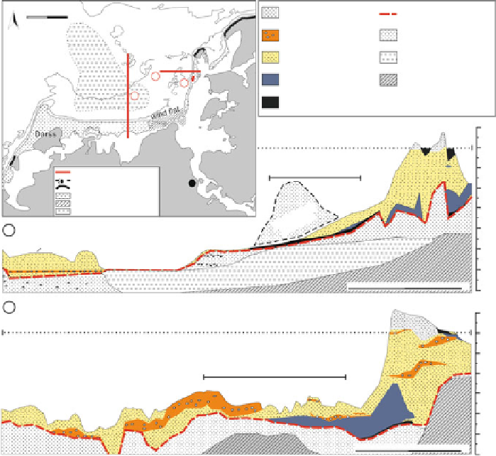
Fig. 12.6
Cross sections of the eastern Zingst peninsula (
1
), Hiddensee island (
2
) and the offshore
areas. The GPR transect marked with (
3
) is shown in Fig.
12.5
as example A and the SES profiles
are shown in Fig.
12.5
as B and C
and the surface of the coastal sediments and calculation of the volume of the barriers.
The sediment volume located at the shoreface was neglected, due to the mostly
uncertain distribution and thickness in the near-coastal zone. The estimated volumes
retreat of the neighbouring cliffs:
(a) In the study areas, no rivers are located, which would deliver significant
amounts of sandy material having the potential for nearshore accumulation.
(b) Due to the many offshore finds of Preboreal, Boreal and Early Atlantic lakes,
mires, forests and archaeological sites, we can exclude any significant erosion
and landward sediment transport to build up the barriers.
The above arguments imply that the predominant part of the barrier sand vol-
ume must have been provided by cliff abrasion, and maybe also to a minor extent
by shoreface abrasion. Considering the height and length of the feeding cliffs, the